Difference between revisions of "Spatial Manager™ for BricsCAD - FAQs: Background Maps ("Standard" and "Professional" editions only)"
m |
m |
||
| (120 intermediate revisions by the same user not shown) | |||
| Line 1: | Line 1: | ||
| + | [[image:SPM BricsCAD Wiki to Website.png|150px|link=http://www.spatialmanager.com/spm-forbricscad/ |Spatial Manager™ for BricsCAD product page]] [[image:SPM BricsCAD Wiki to Download.png|150px|link=http://www.spatialmanager.com/download/spatial-manager-bricscad/ |Download Spatial Manager™ for BricsCAD]] | ||
| + | |||
| + | |||
| + | |||
| + | ''Notes:'' | ||
| + | *''Some components in the images on this page (providers, names, windows look, etc.) may be slightly different from those that will appear on your computer'' | ||
| + | *''Some application functions need to access the Internet from the application itself. If you experiment problems in any process, ask your network administrator if there is a Proxy server installed on your network. You can configure the [[Spatial_Manager%E2%84%A2_for_BricsCAD_-_FAQs:_Interface#Options|Proxy settings through the application options]]'' | ||
| + | |||
| + | |||
| + | |||
===Introduction=== | ===Introduction=== | ||
*'''Objective of this section''' | *'''Objective of this section''' | ||
| Line 15: | Line 25: | ||
===How can I display a 'Background Map' in the drawing?=== | ===How can I display a 'Background Map' in the drawing?=== | ||
| − | You can select an image map model to show as 'Background Map' in the drawing by executing the 'SPMBGMAPSHOW' command of Spatial Manager™ for BricsCAD, which you will find in the "Spatial Manager" ribbon, toolbar or drop-down menu. This will open the "Background Map" window allowing you to select a model from the Maps list. You can find the list arranged using different Groups (Tabs) for the different preset Providers (OpenStreetMap, Mapbox, etc.) and the User groups (see how to [[Spatial_Manager%E2%84%A2_for_BricsCAD_-_FAQs:_Background_Maps_(%22Standard%22_and_%22Professional%22_editions_only)#Can_I_configure_my_own_Web_Map_Services.3F|Configure User 'Background Maps']]). The image of the 'Background Map' is automatically adapted to the current drawing view and it will be automatically fitted when the drawing view changes (zoom, pan, etc.). Compatibility note: the 'Background Maps' are shown properly in the PLAN view of the WCS in the Model space, but the results in other views as well as in the Layouts are unpredictable | + | You can select an image map model to show as 'Background Map' in the drawing by executing the 'SPMBGMAPSHOW' command of Spatial Manager™ for BricsCAD, which you will find in the "Spatial Manager" ribbon, toolbar or drop-down menu. This will open the "Background Map" window allowing you to select a model from the Maps list. You can find the list arranged using different Groups (Tabs) for the different preset Providers (OpenStreetMap, Mapbox, etc.) and the User groups (see how to [[Spatial_Manager%E2%84%A2_for_BricsCAD_-_FAQs:_Background_Maps_(%22Standard%22_and_%22Professional%22_editions_only)#Can_I_configure_my_own_Web_Map_Services.3F|''Configure User 'Background Maps''']]). The image of the dynamic 'Background Map' is automatically adapted to the current drawing view and it will be automatically fitted when the drawing view changes (zoom, pan, etc.) (''read the Note below''). Compatibility note: the 'Background Maps' are shown properly in the PLAN view of the WCS in the Model space, but the results in other views as well as in the Layouts are unpredictable |
| + | |||
| + | |||
| + | ''Note: If you want the Map images to be displayed during running ZOOM or PAN (commands or mouse wheel), please set the value of the RTDISPLAY system variable to zero'' | ||
| + | |||
To change the image model map for the 'Background Map', you can execute again the 'SPMBGMAPSHOW' command. The "Background Map" window will display emphasized the current image map model, which you can keep by clicking in the "OK" button. Click in another model if you want to change to this model | To change the image model map for the 'Background Map', you can execute again the 'SPMBGMAPSHOW' command. The "Background Map" window will display emphasized the current image map model, which you can keep by clicking in the "OK" button. Click in another model if you want to change to this model | ||
| Line 21: | Line 35: | ||
| − | [[Image:BGMapsRibbonBCAD22.PNG|border|'SPMBGMAPSHOW' command in the Spatial Manager™ for BricsCAD Ribbon (Can also be found in the drop-down Menu and Toolbar of Spatial Manager)]] | + | <span title="'SPMBGMAPSHOW' command in the Spatial Manager™ for BricsCAD Ribbon (Can also be found in the drop-down Menu and Toolbar of Spatial Manager)">[[Image:BGMapsRibbonBCAD22.PNG|border|'SPMBGMAPSHOW' command in the Spatial Manager™ for BricsCAD Ribbon (Can also be found in the drop-down Menu and Toolbar of Spatial Manager)|link=]]</span> |
| + | |||
| + | <span title="'Background Map' list window">[[Image:BGMapsListWindowBCAD5.PNG|border|"Background Map" list window|link=]]</span> | ||
| − | + | '''Background Map' models list window'' | |
| − | |||
| + | [[Image:BG5.3BCAD.png|950px|border|'Background Map' applied in a sample drawing|link={{filepath:BG5.3BCAD.png}}]] | ||
| − | + | '''Background Map' sample'' | |
| − | |||
| + | Drawing view behavior when selecting a 'Background Map' and the "Zoom to the map" option: | ||
| + | *There no are entities in the drawing | ||
| + | **If the current view does not intersect the 'Background Map' extent or "Zoom to the map" has been selected, then the view fits to the 'Background Map' extent | ||
| + | **Otherwise the view does not change. For example when you select a different 'Background Map' from the current one, since it is not usually interesting to lose the current view in the drawing | ||
| + | *There are entities in the drawing | ||
| + | **"Zoom to the map" selected | ||
| + | ***If the drawing extent intersects the 'Background Map' extent, then the view fits to the drawing extent (the same effect that BricsCAD "Zoom Extents") | ||
| + | ***Otherwise the view fits to the 'Background Map' extent | ||
| + | **"Zoom to the map" not selected | ||
| + | ***The view does not change. If the current view does not intersect the 'Background Map' extent, a warning alerts you about that the selected 'Background Map' is located outside the current view and that you will not see it in the view | ||
| + | *In any other case not covered above | ||
| + | **The view does not change | ||
| + | ''Notes:'' | ||
| + | *''The 'Background Map' extent is the bounding box defined in the corresponding Map Server and sometimes may be greater than the 'Background Map' geographic extent'' | ||
| + | *''See also the "Notes" in the article [[#Need_to_have_some_reference_in_the_drawing_to_use_the_.27Background_Maps.27.3F | Need to have some reference in the drawing to use the 'Background Maps'?]]'' | ||
| − | " | + | |
| + | "Bring map to front" option: When checked, the map will be overlapped to all the entities in the drawing | ||
| + | |||
| + | |||
| + | <span title="Map in the background vs. foreground">[[Image:BGMap to front2.png|Map in the background vs. foreground|link=]]</span> | ||
| + | |||
| + | |||
| + | ''Notes:'' | ||
| + | *''Bringing the 'Background Map' to front makes sense, and it is a very practical option, when it has any Transparent area (learn more about [[#Does the 'Background Maps' technology support Transparent maps?|Transparent 'Background Maps' support]])'' | ||
| + | *''If you add entities to the drawing after bringing the 'Background Map' to front, those will overlap the 'Background Map'. If you want to put the 'Background Map' back in the foreground, simply select it again and keep checked the option "Bring map to front", or regen the 'Background Map ('SPMBGMAPREFRESH')'' | ||
| + | |||
| + | |||
| + | ''Warning: Bringing the 'Background Map' to front can cause the entities in the drawing to be hidden (except in Transparent areas of the 'Background Map', if any)'' | ||
| Line 44: | Line 86: | ||
| − | [[Image:SPMMapHideBCAD2.png|border|'SPMBGMAPHIDE' command in the Spatial Manager™ for BricsCAD Ribbon (Can also be found in the drop-down Menu and Toolbar of Spatial Manager)]] | + | <span title="'SPMBGMAPHIDE' command in the Spatial Manager™ for BricsCAD Ribbon (Can also be found in the drop-down Menu and Toolbar of Spatial Manager)">[[Image:SPMMapHideBCAD2.png|border|'SPMBGMAPHIDE' command in the Spatial Manager™ for BricsCAD Ribbon (Can also be found in the drop-down Menu and Toolbar of Spatial Manager)|link=]]</span> |
===Need to have some reference in the drawing to use the 'Background Maps'?=== | ===Need to have some reference in the drawing to use the 'Background Maps'?=== | ||
| − | If the drawing is not empty when 'SPMBGMAPSHOW' is executed, it is necessary that the drawing has been assigned a Coordinate Reference System (CRS) in order that the application "knows how-to" adjust the image of the 'Background Map'. If this is not the case, you can assign a CRS to the drawing (and modify it) using the command 'SPMSETCRS' of Spatial Manager™ for BricsCAD. By executing this command you will access the CRS catalog of the application where you can: | + | If the drawing is not empty when 'SPMBGMAPSHOW' is executed, it is necessary that the drawing has been assigned a Coordinate Reference System (CRS) in order that the application "knows how-to" adjust the image of the 'Background Map'. If this is not the case, you can assign a CRS to the drawing (and modify it) using the command 'SPMSETCRS' of Spatial Manager™ for BricsCAD. By executing this command, you will access the CRS catalog of the application where you can: |
*Filter the CRSs by type (Geocentric, Projected, etc.). The type "Projected" will be selected by default because is the most common choice | *Filter the CRSs by type (Geocentric, Projected, etc.). The type "Projected" will be selected by default because is the most common choice | ||
*Choose a CRS by clicking on its row in the table | *Choose a CRS by clicking on its row in the table | ||
| − | *Search CRSs by typing the search criteria in the "Search" box. You can type here as many words as you like separated by blanks. The application will find all the rows including all these words in | + | *Search CRSs by typing the search criteria in the "Search" box. You can type here as many words as you like separated by blanks. The application will find all the rows including all these words in any column of the table |
| − | * | + | *Unassign (undefine) the Coordinate System of the drawing, by choosing "Undefined CRS" (EPSG 0) |
| − | If the drawing is empty when 'SPMBGMAPSHOW' is executed | + | If the drawing is empty and has no coordinate system assigned to it, when 'SPMBGMAPSHOW' is executed Spatial Manager™ for BricsCAD will assign the Background Map CRS to the drawing |
* ''Notes:'' | * ''Notes:'' | ||
| − | **The 'Background Maps' are only available when using '''projected''' Coordinate Reference Systems | + | **''The 'Background Maps' are only available when using '''projected''' Coordinate Reference Systems'' |
| − | **[[Coordinate Systems objects list | Coordinate Systems objects available in the current version'' | + | **''If the drawing has any assigned CRS and the current view is outside the CRS valid area, when selecting a 'Background Map' a warning alerts you about this and about you will not see the 'Background Map' in the view'' |
| + | **[[Coordinate Systems and Transformation details | ''Coordinate Systems and Transformation details'']] | ||
| + | **''[[Coordinate Systems objects list | Coordinate Systems objects available in the current version]]'' | ||
| − | [[Image:SPMSetCrBCAD25-2.png|border|'SPMSETCRS' command in the Spatial Manager™ for BricsCAD Ribbon (Can also be found in the drop-down Menu and Toolbar of Spatial Manager)]] | + | <span title="'SPMSETCRS' command in the Spatial Manager™ for BricsCAD Ribbon (Can also be found in the drop-down Menu and Toolbar of Spatial Manager)">[[Image:SPMSetCrBCAD25-2.png|border|'SPMSETCRS' command in the Spatial Manager™ for BricsCAD Ribbon (Can also be found in the drop-down Menu and Toolbar of Spatial Manager)|link=]]</span> |
| − | [[Image:TC-3.PNG|border|CRS catalog of the application]] | + | <span title="CRS catalog of the application">[[Image:TC-3.PNG|border|CRS catalog of the application|link=]]</span> |
''CRS catalog of the application'' | ''CRS catalog of the application'' | ||
| Line 74: | Line 118: | ||
| − | [[Image:BGMapsConfigureBCAD32.png|border|Configure 'Background Maps' through the selection window]] | + | <span title="Configure 'Background Maps' through the selection window">[[Image:BGMapsConfigureBCAD32.png|border|Configure 'Background Maps' through the selection window|link=]]</span> |
| − | [[Image:BGMapsOptionsACAD3.png|border|Configure 'Background Maps' through the application Options]] | + | <span title="Configure 'Background Maps' through the application Options">[[Image:BGMapsOptionsACAD3.png|border|Configure 'Background Maps' through the application Options|link=]]</span> |
| − | |||
| − | |||
| − | |||
| Line 89: | Line 130: | ||
| − | [[Image:SPM BckMap Limited BCAD2.PNG|border|'Background Maps' blocked]] | + | <span title="'Background Maps' blocked">[[Image:SPM BckMap Limited BCAD2.PNG|border|'Background Maps' blocked|link=]]</span> |
| Line 100: | Line 141: | ||
| − | [[Image:SPMMapRefreshBCAD2.png|border|'SPMBGMAPREFRESH' command in the Spatial Manager™ for BricsCAD Ribbon (Can also be found in the drop-down Menu and Toolbar of Spatial Manager)]] | + | <span title="'SPMBGMAPREFRESH' command in the Spatial Manager™ for BricsCAD Ribbon (Can also be found in the drop-down Menu and Toolbar of Spatial Manager)">[[Image:SPMMapRefreshBCAD2.png|border|'SPMBGMAPREFRESH' command in the Spatial Manager™ for BricsCAD Ribbon (Can also be found in the drop-down Menu and Toolbar of Spatial Manager)|link=]]</span> |
| Line 106: | Line 147: | ||
| − | [[Image:BG_Maps_'Orphan'_tiles.PNG|border|'Background Map' "orphan" image tiles]] | + | <span title="'Background Map' 'orphan' image tiles">[[Image:BG_Maps_'Orphan'_tiles.PNG|border|'Background Map' "orphan" image tiles|link=]]</span> |
| Line 116: | Line 157: | ||
===Can I configure my own Web Map Services?=== | ===Can I configure my own Web Map Services?=== | ||
| − | Yes, you can. Spatial Manager™ for BricsCAD includes the option to define "User Background Maps" in order to enable the access to more Mapping Services ([http://en.wikipedia.org/wiki/Tile_Map_Service TMS] , [http://en.wikipedia.org/wiki/Web_Map_Tile_Service WMTS] or [http://en.wikipedia.org/wiki/Web_Map_Service WMS]) | + | Yes, you can. Spatial Manager™ for BricsCAD includes the option to define "User Background Maps" in order to enable the access to more Mapping Services ([http://en.wikipedia.org/wiki/Tile_Map_Service XYZ / TMS] , [http://en.wikipedia.org/wiki/Web_Map_Tile_Service WMTS] or [http://en.wikipedia.org/wiki/Web_Map_Service WMS]) |
| − | Enter the parameters needed to define a new "User Background Map" through the option "Configure Background Maps" in the application Options (SPMOPTIONS), or through the "Configure | + | Enter the parameters needed to define a new "User Background Map" through the option "Configure Background Maps" in the application Options ('SPMOPTIONS'), or through the "Configure Background Maps" button in the 'Background Maps' selection window ('SPMSPMBGMAPSHOW'). As you will see, you can also Edit or Delete any existing "User Background Map" through the same option |
| − | + | Through the "Configure Background Maps" window you can also Export/Import "User Background Maps" to/from a 'Background Map Definition' file (''*.bmd''). This kind of files includes the definition of one or more 'Background Maps' as well as the Group(s) where they are or will be placed. You can export as many Maps as you want to a single file and, if you are importing already existing Maps, you can choose to either ignore the import of these Maps or rename them using automatic consecutive numbering | |
| + | ''Note: This functionality will allow you to share the Background Maps between computers or users and helps organize user Background Map definitions. In addition, you will be able to Import Maps from services such as [http://www.dronedeploy.com/ DroneDeploy] and others'' | ||
| − | |||
| + | <span title="'Configure Background Maps' in the application Options">[[Image:SPM_BGMAPS_USER_BCAD3.png|"Configure Background Maps" in the application Options|link=]]</span> | ||
| − | *'''TMS Type Maps''' (OSGeo Standard | + | |
| + | <span title="'Configure Background Maps' button in the 'Background Maps' selection window">[[Image:SPM_BGMAPS_USER2_BCAD.png|border|"Configure Background Maps" button in the 'Background Maps' selection window|link=]]</span> | ||
| + | |||
| + | |||
| + | *'''XYZ / TMS Type Maps''' (OSGeo Standard / 256x256 tiles) | ||
**The Name of the Map | **The Name of the Map | ||
| + | ***Each Map will have its own unique Identifier, so you can apply the same Name to different Maps in different Groups | ||
**The Group (Tab) where you want to place the Map. If it comes to a new Group, it will be automatically created. You can dropdown the list of the Groups to place the Map into an existing Group | **The Group (Tab) where you want to place the Map. If it comes to a new Group, it will be automatically created. You can dropdown the list of the Groups to place the Map into an existing Group | ||
| − | **The Type of the Map (TMS in this case) | + | **The Type of the Map (XYZ / TMS in this case) |
**The URL to access a specific valid Map in a valid Map Server. The URL must include the dynamic parameters specified in the application window | **The URL to access a specific valid Map in a valid Map Server. The URL must include the dynamic parameters specified in the application window | ||
| + | ***Authentication: To enter the login data to access the service, if needed (Available security protocols SSL3, TLS, TLS1.2) | ||
| + | ***Advanced options | ||
| + | ****Coordinate System (CRS). Be careful when changing this setting because most XYZ/TMS servers use the default value "WGS84 Pseudo-Mercator (EPSG 3857)", so change only if you are sure another CRS is required | ||
| + | ****Tiles origin (Top-left or Bottom-left) | ||
| − | [[Image: | + | <span title="Configuring 'XYZ / TMS User Background Maps'">[[Image:SPM_BGMAPS_TMS6.png|border|Configuring "XYZ / TMS User Background Maps"|link=]]</span> |
| − | *'''WMS''' or '''WMTS Type Maps''' (OGC Standard | + | *'''WMS''' or '''WMTS Type Maps''' (OGC Standard / any tile size) |
**The Name of the Map | **The Name of the Map | ||
| + | ***The application will you propose a name for the Map based on the selected Layer(s) in the server (see below), but you can modify it if you want to | ||
| + | ***Each Map will have its own unique Identifier, so you can apply the same Name to different Maps in different Groups | ||
**The Group (Tab) where you want to place the Map. If it comes to a new Group, it will be automatically created. You can dropdown the list of the Groups to place the Map into an existing Group | **The Group (Tab) where you want to place the Map. If it comes to a new Group, it will be automatically created. You can dropdown the list of the Groups to place the Map into an existing Group | ||
**The Type of the Map (WMS/WMTS in this case) | **The Type of the Map (WMS/WMTS in this case) | ||
**The URL to access a valid Map Server | **The URL to access a valid Map Server | ||
| − | ***The Layer you want to | + | ***Authentication: To enter the login data to access the service, if needed (Available security protocols SSL3, TLS, TLS1.2) |
| − | ****The Coordinate System (CRS) for the selected Layer. Choose an available CRS from the "Coordinate System" dropdown | + | ***The Layer(s) that you want to include in the 'Background Map'. Click in the "Get List of Layers" button and select the Layer(s) from the tree showing the complete Layers structure available in the Map Server |
| − | ****The Image Format for the selected Layer. Choose an available Format from the "Image Format" dropdown | + | ****The Coordinate System (CRS) for the selected Layer(s). Choose an available CRS or "Automatic" from the "Coordinate System" dropdown |
| + | *****The default "Automatic" option automatically configures the map CRS trying to find the best choice, by following the next process: | ||
| + | ******The same CRS as the current drawing CRS | ||
| + | ******If not available the previous one, then the CRS "WGS 84 / Pseudo-Mercator (SRID 3857)" | ||
| + | ******If the previous one is not available either, then the first CRS available in the server list | ||
| + | ******''Note: This setting is a dynamic option because the application will reload the map whenever there are changes of the drawing CRS'' | ||
| + | ****The Image Format for the selected Layer(s). Choose an available Format from the "Image Format" dropdown | ||
| + | *****The default "Automatic" option automatically sets the most suitable Image format, by following the next process: | ||
| + | ******PNG | ||
| + | ******If PNG is not available, then any PNG variant (PNG8, etc.) | ||
| + | ******If the previous option is not available either, then JPG | ||
| + | ******If JPG is not available, then the first format available in the server list | ||
| + | ****The Download method from the server: "Single image (recommended)" or "Image tiles grid" (WMS only) | ||
| + | ****The Map Background Color (solid or transparent) (only for WMS servers that support it) | ||
| + | *****Transparent maps: See the next section | ||
| + | |||
| + | |||
| + | <span title="Configuring 'WMTS or WMS User Background Maps'">[[Image:SPM_BGMAPS_WMTS-WMS4.png|border|Configuring "WMTS or WMS User Background Maps"|link=]]</span> | ||
| − | + | Notes about the WMS/WMTS 'Background Maps' performance: | |
| + | *Whenever possible select the Coordinate System (CRS) assigned to the drawing in the 'Background Map' configuration | ||
| + | **No CRS Transformation implies avoiding the deformation of the Map images while maintaining their original visual quality | ||
| + | **In most cases, the default "Automatic" option (see above) is the best one | ||
| + | *When configuring the "Download method" for a WMS 'Background Map', choose the default option "Single image (recommended)" whenever possible | ||
| + | **The image quality is optimum | ||
| + | **This choice will assure that not be shown texts or other elements repeated multiple times when they appear in more than one image tile | ||
| + | **The alternative "Image tiles grid" should be used only when the "Single image" option becomes too slow | ||
| + | *Select any compressed image format (PNG, JPG, etc.) if available | ||
| + | **The images will be smaller resulting in shorter download times | ||
| + | **In most cases, the default "Automatic" option (see above) is the best one | ||
When configuring a User Map, clicking in the "Show Preview" button will display an image of the Map extension in order to help you verifying if all settings are correct. The "Preview" image will be automatically updated when you modify any configuration parameter | When configuring a User Map, clicking in the "Show Preview" button will display an image of the Map extension in order to help you verifying if all settings are correct. The "Preview" image will be automatically updated when you modify any configuration parameter | ||
| + | |||
| + | |||
| + | Click in the "Save" button to save the Map and exit, or click in the button "Save as a copy" to save the Map and stay on this window. This option allows you to quickly create various Maps using similar configurations without having to go out and come back again and again. For example, in the case of WMS/WMTS Maps it is very useful for easily creating different Maps that include different Layer(s) of the same source | ||
| + | |||
| + | |||
| + | |||
| + | ===Does the 'Background Maps' technology support Transparent maps?=== | ||
| + | Yes, Spatial Manager™ for BricsCAD supports 'Background Maps' that include Transparency information. Using Transparent maps will allow you to get visually richer maps by combining different map models in your drawings. You can further improve this feature if you use it in conjunction with the "Snapshots" (''see the next section'') | ||
| + | |||
| + | If you select any Transparent 'Background Map' to show it, and the option "Bring map to front" is checked when selecting the 'Background Map', you will see the opaque areas of the 'Background Map' over the entities in your drawing (see the option "Bring map to front" in [[#How can I display a 'Background Map' in the drawing?|''How can I display a 'Background Map' in the drawing?'']]) | ||
| + | |||
| + | |||
| + | <span title="Combining Transparent 'Background Maps'">[[Image:SPM_BGMaps_Transparent2.png|border|Combining Transparent 'Background Maps'|link=]]</span> | ||
| + | |||
| + | |||
| + | ''Note: Transforming coordinates of the resulting images of a map (if needed), it is a little slower when a Transparent 'Background Map' is shown in drawing'' | ||
===Is there any way to get static "Snapshots" of the 'Background Maps'?=== | ===Is there any way to get static "Snapshots" of the 'Background Maps'?=== | ||
| − | Yes, Spatial Manager™ for BricsCAD includes the command SPMBGMAPIMAGE that allows you to create (capture) a | + | Yes, Spatial Manager™ for BricsCAD includes the command 'SPMBGMAPIMAGE' that allows you to create (capture) a snapshot corresponding to the current view or a custom area of the shown 'Background Map' |
| − | [[Image:SpatialManagerforBricsCAD-CaptureImageCommand.png|border|'SPMBGMAPIMAGE' command in the | + | <span title="'SPMBGMAPIMAGE' command in the Spatial Manager™ for BricsCAD ribbon (Can also be found in the drop-down Menu and Toolbar of Spatial Manager)">[[Image:SpatialManagerforBricsCAD-CaptureImageCommand.png|border|'SPMBGMAPIMAGE' command in the Spatial Manager™ for BricsCAD ribbon (Can also be found in the drop-down Menu and Toolbar of Spatial Manager)|link=]]</span> |
| − | As you will see, you can choose between four levels of image | + | As you will see, you can choose between four levels of map image detail, and select if you want an externally referenced BricsCAD Raster Image (the drawing must be saved so that the application "knows" where the new image must be stored) or an embebed OLE Image. In addition, in the first case you can select the image format and if you want to attach a [http://en.wikipedia.org/wiki/World_file ''World File''] in order to geo-reference the saved image |
| − | [[Image:SpatialManagerforAutoCAD-CaptureImageResolution.png|border| | + | <span title="Image Capture options window">[[Image:SpatialManagerforAutoCAD-CaptureImageResolution.png|border|Image Capture options window|link=]]</span> |
| − | This command allows you many advanced graphic options when using 'Background Maps' as well as solving some Printing issues, | + | This command allows you many advanced graphic options when using 'Background Maps' as well as solving some Printing issues, which are discussed in the next paragraph |
| − | [[Image:SPMCombinedMaps3.PNG|border|Combining Raster Images or Images with 'Background Maps']] | + | <span title="Combining Raster Images or Images with 'Background Maps'">[[Image:SPMCombinedMaps3.PNG|border|Combining Raster Images or Images with 'Background Maps'|link=]]</span> |
| Line 180: | Line 276: | ||
| − | [[Image:SPMBricsCAD Plot area.PNG|border|Selecting BricsCAD "Plot area"]] | + | <span title="Selecting BricsCAD 'Plot area'">[[Image:SPMBricsCAD Plot area.PNG|border|Selecting BricsCAD "Plot area"|link=]]</span> |
| − | [[Image:Spatial Manager Snapshots AutoCAD 2.PNG|border|Different 'Background Maps' views (Snapshots) in different Viewports]] | + | <span title="Different 'Background Maps' views (Snapshots) in different Viewports">[[Image:Spatial Manager Snapshots AutoCAD 2.PNG|border|Different 'Background Maps' views (Snapshots) in different Viewports|link=]]</span> |
| + | |||
| + | |||
| + | |||
| + | ===Can I enhance the quality of the 'Background Maps'?=== | ||
| + | Yes, in Spatial Manager™ for BricsCAD you can increase/reduce the Map images quality (at the cost of losing/winning performance), through the "Images quality" option that you will find in the "Background Maps" section of the application Options ('SPMOPTIONS') | ||
| + | |||
| + | |||
| + | <span title="'Images quality' option">[[Image:CAD_Image_quality2.png|border|"Images quality" option|link=]]</span> | ||
| + | |||
| + | |||
| + | ''Notes:'' | ||
| + | *''The quality improvement will be more appreciable depending on your graphic system, the zoom level and the selected 'Background Map''' | ||
| + | **''In addition as discussed above, the quality improvements may be more necessary if the CRS of the Map must be transformed, as the resulting Map images will be obtained by deforming rectangular frames'' | ||
| + | *''The BricsCAD command 'IMAGEQUALITY' (Draft/High) can also affect to the 'Background Maps' quality'' | ||
| + | |||
| + | |||
| + | <span title="'Images quality' sample results">[[Image:Image_quality_1_to_4.png|"Images quality" sample results|link=]]</span> | ||
| Line 191: | Line 304: | ||
*[http://www.spatialmanager.com/ordnance-survey-in-bricscad/ Ordnance Survey in BricsCAD] | *[http://www.spatialmanager.com/ordnance-survey-in-bricscad/ Ordnance Survey in BricsCAD] | ||
*[http://www.spatialmanager.com/openstreetmap-classic-map-in-autocad-and-bricscad/ OpenStreetMap “classic look” in BricsCAD] | *[http://www.spatialmanager.com/openstreetmap-classic-map-in-autocad-and-bricscad/ OpenStreetMap “classic look” in BricsCAD] | ||
| − | *[http://www.spatialmanager.com/snapshots-of-background-maps/ Snapshots of Background | + | *[http://www.spatialmanager.com/snapshots-of-background-maps/ Snapshots of Background Maps] |
*[http://www.spatialmanager.com/support-for-ordnance-survey-schema-9-products/ Support for Ordnance Survey – Schema 9 products] | *[http://www.spatialmanager.com/support-for-ordnance-survey-schema-9-products/ Support for Ordnance Survey – Schema 9 products] | ||
*[http://www.spatialmanager.com/background_map_layer_in_exported_pdfs/ Background Map Layer in exported PDFs] | *[http://www.spatialmanager.com/background_map_layer_in_exported_pdfs/ Background Map Layer in exported PDFs] | ||
| + | *[http://www.spatialmanager.com/enhanced_background_maps_wms_wmts_services/ Enhanced Background Maps. WMS & WMTS services] | ||
| + | *[http://www.spatialmanager.com/enhance-the-map-images-quality/ Enhance the Map images quality] | ||
| + | *[http://www.spatialmanager.com/google-maps-in-your-cad-drawings-of-course/ Google Maps in your BricsCAD drawings? Of course] | ||
| + | *[http://www.spatialmanager.com/more-about-dynamic-google-maps-in-your-drawings-or-maps/ More about dynamic Google Maps in your BricsCAD drawings] | ||
| + | *[http://www.spatialmanager.com/rtdisplay-effects-on-the-background-map-images/ RTDISPLAY effects on the Background Map images] | ||
| + | *[http://www.spatialmanager.com/bring-background-maps-to-front/ Bring Background Maps to front] | ||
| + | *[http://www.spatialmanager.com/geo-referencing-captured-images-from-maps/ Geo-referencing captured images from Maps] | ||
| + | *[http://www.spatialmanager.com/dronedeploy-integration/ DroneDeploy integration] | ||
| + | *[http://www.spatialmanager.com/map_servers_sub-domains/ Map servers sub-domains] | ||
| + | *[http://www.spatialmanager.com/adding-openstreetmap-or-google-maps-objects-to-your-maps/ Adding OpenStreetMap or Google Maps objects to your maps] | ||
| + | *[http://www.spatialmanager.com/exporting-importing-user-background-map-defintions/ Exporting-Importing user Background Map defintions] | ||
| + | *[http://www.spatialmanager.com/traffic-and-transit-in-google-maps/ Traffic and transit in Google Maps] | ||
| + | *[http://www.spatialmanager.com/custom-areas-and-ole-objects-when-snapshoting/ Custom areas and OLE objects when Snapshoting] | ||
| + | *[http://www.spatialmanager.com/setting-up-the-bg-maps-transparency-or-background-color/ Setting up the BG Maps transparency or background color] | ||
| + | *[http://www.spatialmanager.com/how-to-access-yandex-maps/ How to access Yandex maps] | ||
| + | *[http://www.spatialmanager.com/nearmap-oblique-maps/ NearMap Oblique maps] | ||
| + | *[http://www.spatialmanager.com/how-to-access-opentopomap-map/ OpenTopoMap and more German maps in your drawings] | ||
| + | *[http://www.spatialmanager.com/8-new-bing-maps-added-in-spm-v6/ 8 New Bing maps added in SPM v6] | ||
| + | *[http://www.spatialmanager.com/mapbox-customized-maps-in-cad-and-desktop/ Mapbox customized maps in BricsCAD] | ||
| + | *[http://www.spatialmanager.com/trim-localized-image-maps/ Trim localized Image Maps] | ||
*[[Spatial Manager™ for BricsCAD#FAQs|Go to FAQS]] | *[[Spatial Manager™ for BricsCAD#FAQs|Go to FAQS]] | ||
| + | |||
| + | |||
| + | |||
| + | [[image:SPM BricsCAD Wiki to Website.png|150px|link=http://www.spatialmanager.com/spm-forbricscad/ |Spatial Manager™ for BricsCAD product page]] [[image:SPM BricsCAD Wiki to Download.png|150px|link=http://www.spatialmanager.com/download/spatial-manager-bricscad/ |Download Spatial Manager™ for BricsCAD]] | ||
Revision as of 19:06, 21 July 2020
![]()
![]()
Notes:
- Some components in the images on this page (providers, names, windows look, etc.) may be slightly different from those that will appear on your computer
- Some application functions need to access the Internet from the application itself. If you experiment problems in any process, ask your network administrator if there is a Proxy server installed on your network. You can configure the Proxy settings through the application options
Introduction
- Objective of this section
- To learn how to show image Maps in the Background of the drawings, which can enhance their quality as well as make them more understandable
- Topics in this section
- Select 'Background Maps' models
- Show / Hide 'Background Maps'
- Reference for 'Background Maps'
- Configure User 'Background Maps'
- Some other tools such as "Refresh" or Regen and "Clean" the 'Background Map' under special conditions
- Take "Snapshots" of the 'Background Maps'
- Print drawings including 'Background Maps'
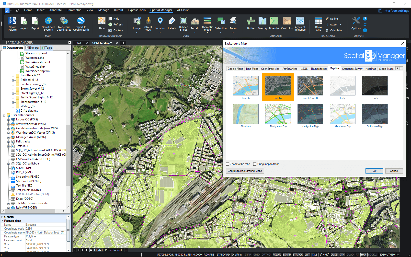
How can I display a 'Background Map' in the drawing?
You can select an image map model to show as 'Background Map' in the drawing by executing the 'SPMBGMAPSHOW' command of Spatial Manager™ for BricsCAD, which you will find in the "Spatial Manager" ribbon, toolbar or drop-down menu. This will open the "Background Map" window allowing you to select a model from the Maps list. You can find the list arranged using different Groups (Tabs) for the different preset Providers (OpenStreetMap, Mapbox, etc.) and the User groups (see how to Configure User 'Background Maps'). The image of the dynamic 'Background Map' is automatically adapted to the current drawing view and it will be automatically fitted when the drawing view changes (zoom, pan, etc.) (read the Note below). Compatibility note: the 'Background Maps' are shown properly in the PLAN view of the WCS in the Model space, but the results in other views as well as in the Layouts are unpredictable
Note: If you want the Map images to be displayed during running ZOOM or PAN (commands or mouse wheel), please set the value of the RTDISPLAY system variable to zero
To change the image model map for the 'Background Map', you can execute again the 'SPMBGMAPSHOW' command. The "Background Map" window will display emphasized the current image map model, which you can keep by clicking in the "OK" button. Click in another model if you want to change to this model
")

'Background Map' models list window
'Background Map' sample
Drawing view behavior when selecting a 'Background Map' and the "Zoom to the map" option:
- There no are entities in the drawing
- If the current view does not intersect the 'Background Map' extent or "Zoom to the map" has been selected, then the view fits to the 'Background Map' extent
- Otherwise the view does not change. For example when you select a different 'Background Map' from the current one, since it is not usually interesting to lose the current view in the drawing
- There are entities in the drawing
- "Zoom to the map" selected
- If the drawing extent intersects the 'Background Map' extent, then the view fits to the drawing extent (the same effect that BricsCAD "Zoom Extents")
- Otherwise the view fits to the 'Background Map' extent
- "Zoom to the map" not selected
- The view does not change. If the current view does not intersect the 'Background Map' extent, a warning alerts you about that the selected 'Background Map' is located outside the current view and that you will not see it in the view
- "Zoom to the map" selected
- In any other case not covered above
- The view does not change
Notes:
- The 'Background Map' extent is the bounding box defined in the corresponding Map Server and sometimes may be greater than the 'Background Map' geographic extent
- See also the "Notes" in the article Need to have some reference in the drawing to use the 'Background Maps'?
"Bring map to front" option: When checked, the map will be overlapped to all the entities in the drawing

Notes:
- Bringing the 'Background Map' to front makes sense, and it is a very practical option, when it has any Transparent area (learn more about Transparent 'Background Maps' support)
- If you add entities to the drawing after bringing the 'Background Map' to front, those will overlap the 'Background Map'. If you want to put the 'Background Map' back in the foreground, simply select it again and keep checked the option "Bring map to front", or regen the 'Background Map ('SPMBGMAPREFRESH')
Warning: Bringing the 'Background Map' to front can cause the entities in the drawing to be hidden (except in Transparent areas of the 'Background Map', if any)
How can I hide the 'Background Map' in the drawing?
You can hide the 'Background Map' that is shown in the drawing by executing the 'SPMBGMAPHIDE' command of Spatial Manager™ for BricsCAD, which you will find in the "Spatial Manager" ribbon, toolbar or drop-down menu
If you want to display a 'Background Map', you need to execute the 'SPMBGMAPSHOW' command again
")
Need to have some reference in the drawing to use the 'Background Maps'?
If the drawing is not empty when 'SPMBGMAPSHOW' is executed, it is necessary that the drawing has been assigned a Coordinate Reference System (CRS) in order that the application "knows how-to" adjust the image of the 'Background Map'. If this is not the case, you can assign a CRS to the drawing (and modify it) using the command 'SPMSETCRS' of Spatial Manager™ for BricsCAD. By executing this command, you will access the CRS catalog of the application where you can:
- Filter the CRSs by type (Geocentric, Projected, etc.). The type "Projected" will be selected by default because is the most common choice
- Choose a CRS by clicking on its row in the table
- Search CRSs by typing the search criteria in the "Search" box. You can type here as many words as you like separated by blanks. The application will find all the rows including all these words in any column of the table
- Unassign (undefine) the Coordinate System of the drawing, by choosing "Undefined CRS" (EPSG 0)
If the drawing is empty and has no coordinate system assigned to it, when 'SPMBGMAPSHOW' is executed Spatial Manager™ for BricsCAD will assign the Background Map CRS to the drawing
- Notes:
- The 'Background Maps' are only available when using projected Coordinate Reference Systems
- If the drawing has any assigned CRS and the current view is outside the CRS valid area, when selecting a 'Background Map' a warning alerts you about this and about you will not see the 'Background Map' in the view
- Coordinate Systems and Transformation details
- Coordinate Systems objects available in the current version
")

CRS catalog of the application
Is there any special condition to use the 'Background Maps'?
Certain image maps providers included in Spatial Manager™ for BricsCAD may require special terms of use for the users of their maps. You can configure any special setting needed to load the maps of such providers through the 'Background Maps' selection window ('SPMBGMAPSHOW') or through the application Options ('SPMOPTIONS'). You can also configure and save settings the first time you try to use ('SPMBGMAPSHOW') a 'Background Map' that needs a special configuration
Configure 'Background Maps' through the selection window
Configure 'Background Maps' through the application Options
You can change the settings as often as desired. You can even insert blank values to reset the values of these settings
Sometimes, the image maps provider lets you access to some free maps but you need to get a key or code to use the others. In this case you will see "blocked" the maps which need that you modify the configuration according to the instructions above

Important note: Please, read also the specific license conditions in the paragraph relating to the 'Background Maps' of the application End User License Agreement (EULA)
Is there any way to "repair" or "clean" the image of the 'Background Map'?
There may be situations where the image of the 'Background Map' in the drawing shows up as broken, incomplete, etc. Most of these issues can be solved through a regeneration ('REGEN') of the drawing. However, some problems may appear which require you "to refresh" the image using the 'SPMBGMAPREFRESH' command of Spatial Manager™ for BricsCAD
")
In certain cases, the image tiles of the 'Background Map' become "orphans", the map is not shown, the frames of the tiles are displayed but these tiles cannot be deleted using BricsCAD commands. 'Spatial Manager™ for BricsCAD' includes the command 'SPMBGMAPIMAGEPURGE' that will delete them

In addition, this command will purge any non-referenced Raster Image in the drawing created using 'SPMBGIMAGE' (Snapshots; see below) and that have been deleted later by the user
Note that when running this command the 'Background Map' will be hidden (if shown) and the complete cleaning process may be time consuming depending on the number of entities in the drawing
Can I configure my own Web Map Services?
Yes, you can. Spatial Manager™ for BricsCAD includes the option to define "User Background Maps" in order to enable the access to more Mapping Services (XYZ / TMS , WMTS or WMS)
Enter the parameters needed to define a new "User Background Map" through the option "Configure Background Maps" in the application Options ('SPMOPTIONS'), or through the "Configure Background Maps" button in the 'Background Maps' selection window ('SPMSPMBGMAPSHOW'). As you will see, you can also Edit or Delete any existing "User Background Map" through the same option
Through the "Configure Background Maps" window you can also Export/Import "User Background Maps" to/from a 'Background Map Definition' file (*.bmd). This kind of files includes the definition of one or more 'Background Maps' as well as the Group(s) where they are or will be placed. You can export as many Maps as you want to a single file and, if you are importing already existing Maps, you can choose to either ignore the import of these Maps or rename them using automatic consecutive numbering
Note: This functionality will allow you to share the Background Maps between computers or users and helps organize user Background Map definitions. In addition, you will be able to Import Maps from services such as DroneDeploy and others


- XYZ / TMS Type Maps (OSGeo Standard / 256x256 tiles)
- The Name of the Map
- Each Map will have its own unique Identifier, so you can apply the same Name to different Maps in different Groups
- The Group (Tab) where you want to place the Map. If it comes to a new Group, it will be automatically created. You can dropdown the list of the Groups to place the Map into an existing Group
- The Type of the Map (XYZ / TMS in this case)
- The URL to access a specific valid Map in a valid Map Server. The URL must include the dynamic parameters specified in the application window
- Authentication: To enter the login data to access the service, if needed (Available security protocols SSL3, TLS, TLS1.2)
- Advanced options
- Coordinate System (CRS). Be careful when changing this setting because most XYZ/TMS servers use the default value "WGS84 Pseudo-Mercator (EPSG 3857)", so change only if you are sure another CRS is required
- Tiles origin (Top-left or Bottom-left)
- The Name of the Map

- WMS or WMTS Type Maps (OGC Standard / any tile size)
- The Name of the Map
- The application will you propose a name for the Map based on the selected Layer(s) in the server (see below), but you can modify it if you want to
- Each Map will have its own unique Identifier, so you can apply the same Name to different Maps in different Groups
- The Group (Tab) where you want to place the Map. If it comes to a new Group, it will be automatically created. You can dropdown the list of the Groups to place the Map into an existing Group
- The Type of the Map (WMS/WMTS in this case)
- The URL to access a valid Map Server
- Authentication: To enter the login data to access the service, if needed (Available security protocols SSL3, TLS, TLS1.2)
- The Layer(s) that you want to include in the 'Background Map'. Click in the "Get List of Layers" button and select the Layer(s) from the tree showing the complete Layers structure available in the Map Server
- The Coordinate System (CRS) for the selected Layer(s). Choose an available CRS or "Automatic" from the "Coordinate System" dropdown
- The default "Automatic" option automatically configures the map CRS trying to find the best choice, by following the next process:
- The same CRS as the current drawing CRS
- If not available the previous one, then the CRS "WGS 84 / Pseudo-Mercator (SRID 3857)"
- If the previous one is not available either, then the first CRS available in the server list
- Note: This setting is a dynamic option because the application will reload the map whenever there are changes of the drawing CRS
- The default "Automatic" option automatically configures the map CRS trying to find the best choice, by following the next process:
- The Image Format for the selected Layer(s). Choose an available Format from the "Image Format" dropdown
- The default "Automatic" option automatically sets the most suitable Image format, by following the next process:
- PNG
- If PNG is not available, then any PNG variant (PNG8, etc.)
- If the previous option is not available either, then JPG
- If JPG is not available, then the first format available in the server list
- The default "Automatic" option automatically sets the most suitable Image format, by following the next process:
- The Download method from the server: "Single image (recommended)" or "Image tiles grid" (WMS only)
- The Map Background Color (solid or transparent) (only for WMS servers that support it)
- Transparent maps: See the next section
- The Coordinate System (CRS) for the selected Layer(s). Choose an available CRS or "Automatic" from the "Coordinate System" dropdown
- The Name of the Map

Notes about the WMS/WMTS 'Background Maps' performance:
- Whenever possible select the Coordinate System (CRS) assigned to the drawing in the 'Background Map' configuration
- No CRS Transformation implies avoiding the deformation of the Map images while maintaining their original visual quality
- In most cases, the default "Automatic" option (see above) is the best one
- When configuring the "Download method" for a WMS 'Background Map', choose the default option "Single image (recommended)" whenever possible
- The image quality is optimum
- This choice will assure that not be shown texts or other elements repeated multiple times when they appear in more than one image tile
- The alternative "Image tiles grid" should be used only when the "Single image" option becomes too slow
- Select any compressed image format (PNG, JPG, etc.) if available
- The images will be smaller resulting in shorter download times
- In most cases, the default "Automatic" option (see above) is the best one
When configuring a User Map, clicking in the "Show Preview" button will display an image of the Map extension in order to help you verifying if all settings are correct. The "Preview" image will be automatically updated when you modify any configuration parameter
Click in the "Save" button to save the Map and exit, or click in the button "Save as a copy" to save the Map and stay on this window. This option allows you to quickly create various Maps using similar configurations without having to go out and come back again and again. For example, in the case of WMS/WMTS Maps it is very useful for easily creating different Maps that include different Layer(s) of the same source
Does the 'Background Maps' technology support Transparent maps?
Yes, Spatial Manager™ for BricsCAD supports 'Background Maps' that include Transparency information. Using Transparent maps will allow you to get visually richer maps by combining different map models in your drawings. You can further improve this feature if you use it in conjunction with the "Snapshots" (see the next section)
If you select any Transparent 'Background Map' to show it, and the option "Bring map to front" is checked when selecting the 'Background Map', you will see the opaque areas of the 'Background Map' over the entities in your drawing (see the option "Bring map to front" in How can I display a 'Background Map' in the drawing?)

Note: Transforming coordinates of the resulting images of a map (if needed), it is a little slower when a Transparent 'Background Map' is shown in drawing
Is there any way to get static "Snapshots" of the 'Background Maps'?
Yes, Spatial Manager™ for BricsCAD includes the command 'SPMBGMAPIMAGE' that allows you to create (capture) a snapshot corresponding to the current view or a custom area of the shown 'Background Map'
")
As you will see, you can choose between four levels of map image detail, and select if you want an externally referenced BricsCAD Raster Image (the drawing must be saved so that the application "knows" where the new image must be stored) or an embebed OLE Image. In addition, in the first case you can select the image format and if you want to attach a World File in order to geo-reference the saved image

This command allows you many advanced graphic options when using 'Background Maps' as well as solving some Printing issues, which are discussed in the next paragraph

Is it necessary to have some special consideration when Printing or Plotting 'Background Maps'?
When Printing/Plotting from BricsCAD you have to be aware that the only way to be sure about the appropriate printed results will be by running the process from the Model Space and selecting "Current view" as the "Plot area" (see the first image below). In other cases the results may not be correct and it would be necessary to apply the following workaround
To Print or Plot any other area of the Model Space, or do it from the Paper Space, or Publishing, etc., the use of the Raster Images captured as indicated in the previous article may be the best solution. In the case of Paper Space Viewports, note that these Raster Images are BricsCAD entities which will allow you to "play" with different possibilities depending on the Layer where they are included and how this Layer is configured in the different Viewports (see the second image below)

 in different Viewports")
Can I enhance the quality of the 'Background Maps'?
Yes, in Spatial Manager™ for BricsCAD you can increase/reduce the Map images quality (at the cost of losing/winning performance), through the "Images quality" option that you will find in the "Background Maps" section of the application Options ('SPMOPTIONS')

Notes:
- The quality improvement will be more appreciable depending on your graphic system, the zoom level and the selected 'Background Map'
- In addition as discussed above, the quality improvements may be more necessary if the CRS of the Map must be transformed, as the resulting Map images will be obtained by deforming rectangular frames
- The BricsCAD command 'IMAGEQUALITY' (Draft/High) can also affect to the 'Background Maps' quality

Related links
- V3: Amazing Background Maps in BricsCAD
- Ordnance Survey in BricsCAD
- OpenStreetMap “classic look” in BricsCAD
- Snapshots of Background Maps
- Support for Ordnance Survey – Schema 9 products
- Background Map Layer in exported PDFs
- Enhanced Background Maps. WMS & WMTS services
- Enhance the Map images quality
- Google Maps in your BricsCAD drawings? Of course
- More about dynamic Google Maps in your BricsCAD drawings
- RTDISPLAY effects on the Background Map images
- Bring Background Maps to front
- Geo-referencing captured images from Maps
- DroneDeploy integration
- Map servers sub-domains
- Adding OpenStreetMap or Google Maps objects to your maps
- Exporting-Importing user Background Map defintions
- Traffic and transit in Google Maps
- Custom areas and OLE objects when Snapshoting
- Setting up the BG Maps transparency or background color
- How to access Yandex maps
- NearMap Oblique maps
- OpenTopoMap and more German maps in your drawings
- 8 New Bing maps added in SPM v6
- Mapbox customized maps in BricsCAD
- Trim localized Image Maps
![]()
![]()