Spatial Manager™ for AutoCAD - FAQs: Transform drawings Coordinate System ("Professional" edition only)
![]()
![]()
Notes:
- Some components in the images on this page (providers, names, windows look, etc.) may be slightly different from those that will appear on your computer
- Some application functions need to access the Internet from the application itself. If you experiment problems in any process, ask your network administrator if there is a Proxy server installed on your network. You can configure the Proxy settings through the application options
Warning: The drawing Coordinate System Transformation functionality may cause some problems or may not be available in versions earlier than AutoCAD 2015 (and may also depend on the version of the Operating System used)
Introduction
- Objective of this section
- To learn how to define the Transformation of a drawing Coordinate System
- Topics in this section
- Coordinate Transformation
- Objects selection
- Source and Target Coordinate Systems and transformation parameters
Can I transform the objects geometry by defining a Transformation of the drawing Coordinate System?
You can transform the Coordinate System (CRS) of a whole drawing or a set of selected objects by executing the 'SPMTRANSFORMCRS' command of Spatial Manager™ for AutoCAD, which automatically creates a new drawing including geometrically regenerated objects from the current drawing according to the chosen transformation between two CRSs. At the end of the transformation process, the newly generated drawing will also be automatically opened. This functionality has been designed to execute this Transformation in a direct and highly automated way, regardless of whether other application functions can perform geometric transformation operations between Coordinate Systems of objects or Background Map images, if these are necessary in Import, Export, Background Maps, etc. processes


Transform drawing Coordinate System functionality (Original and transformed drawings overlapped in order to show the transformation)
- Transformation selection
- Select all objects: all objects in the drawing will be transformed
- Only selected objects: only a selection of objects will be transformed. You can select the objects before executing this command or by using the Selecting buttons in this window
- Manual selection
- Select by Query: select objects according to the result of a simplex or compound data query (See "Selecting by Query")
- Select by Table: select objects which have been previously attached to a specific data table (See "Selecting by Table")
- Select objects in a layer: only the objects included in an AutoCAD Layer will be transformed. You can select the layer using the drop-down list in this window
- Note: When choosing the option to transform all objects in the drawing, those objects that are in locked, off or frozen layers will be also included. If the objects are selected by any means before transforming and the option to transform the selected objects is chosen, they will be transformed even if they are in locked, off or frozen layers
- Objects report
- The application shows here the total number of the objects which will be transformed and any warnings prior to the transformation process, such as the total number of unsupported objects which will not be transformed or others
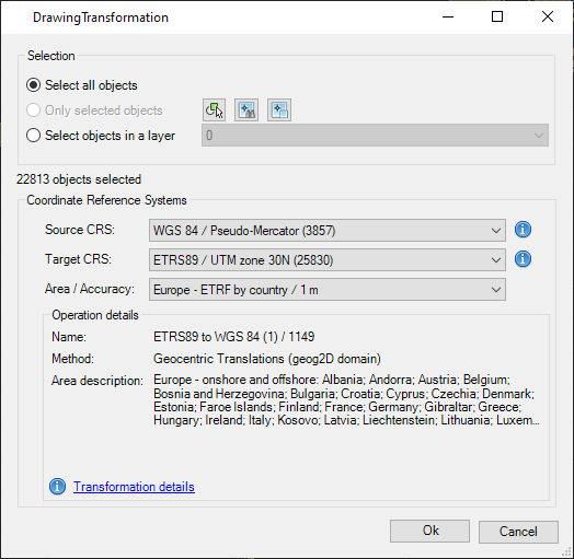
- Coordinate Reference Systems
- Source CRS and Target CRS used in the transformation process. Read more about selecting CRSs in the next article
- If the drawing to be transformed has already a CRS assigned to it (by using SPMSETCRS or by any other automatic assignment method), this CRS will be selected by default, although you can select any other if for any reason this parameter is not appropriate
- Click on the Information button next to any of the drop-down lists in order to get more info about the selected CRS
- Area / Accuracy: after selecting a pair of valid CRSs for the transformation, you need to choose the geographic Area to apply it to (the application will choose by default the most common Area for this transformation)
- Operation details: summary of the transformation operation to be processed. Click on Transformation details at the window bottom in order to get a detailed information on this process
- Source CRS and Target CRS used in the transformation process. Read more about selecting CRSs in the next article
Note: If a Background Map is shown in the source drawing, it will be hidden when the transformation process starts
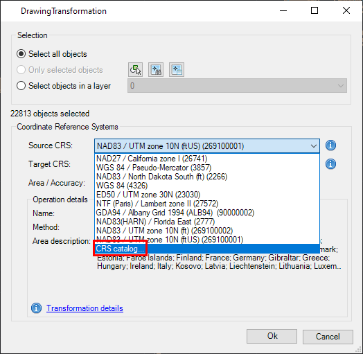
How can I select the Source and Target Coordinate Systems for a Transformation process?
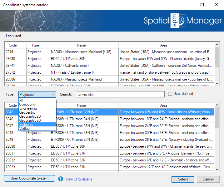
You can choose the appropriate CRSs by clicking on "CRS catalog...", in the CRS dropdown list for the source or for the target data. In the CRS Catalog table you can:
- Filter the CRSs by type (Geocentric, Projected, etc.)
- Choose a CRS by clicking on its row in the table
- Search CRSs by typing the search criteria in the "Search" box. You can type here as many words as you like separated by blanks. The application will find all the rows including all these words in any column of the table
- As you will see, the CRS dropdown lists will include more and more CRSs as they have been previously chosen in other Transformation operations, so that you can choose your "last-used" CRSs directly from the dropdown list without having to access the CRS Catalog all the time. In addition, the CRS Catalog window also includes a list of the "last-used" CRSs (if any) in the upper zone
- Coordinate Systems objects available in the current version
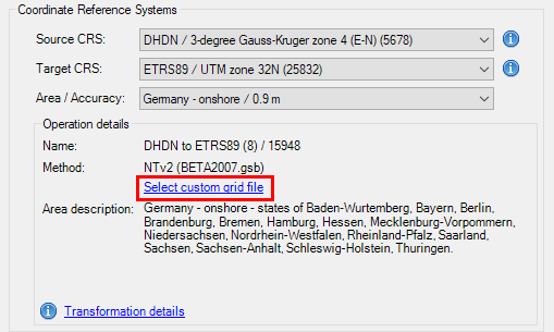
- Notes about transformation Grid files:
- Some coordinate transformations (NTv2, etc.) require one or more Grid files in order to be processed. Some of the most commonly used Grid files worldwide are included in the application, but you can see that some others instruct you on where to download Grid file(s) not included with the application (usually a download URL)
- On the other hand, even if the required Grid file(s) already exists (included as standard in the application, or previously downloaded by the user), the application allows the user to choose an alternative Grid file(s) so that he can use more accurate or updated Grid transformations when more appropriated files are available. This custom choice for a Grid file is kept by default for a work session, but will not be memorized when exiting and re-entering the application
Related links
![]()
![]()