Difference between revisions of "Spatial Manager™ for AutoCAD - FAQs: GIS Analysis ("Professional" edition only)"
m |
m |
||
| Line 11: | Line 11: | ||
===Introduction=== | ===Introduction=== | ||
*'''Objective of this section''' | *'''Objective of this section''' | ||
| − | ** | + | **To leran how to use advanced GIS analysis tools in your drawings and maps |
*'''Topics in this section''' | *'''Topics in this section''' | ||
| − | ** | + | **Create Buffers form point, linear or polygonal borders |
| + | **Process spatial Overlays which will create new drawing objects based on the operation results | ||
| + | **Dissolve polyonal objects in order to create surrounds of adjacent objects | ||
| + | ** | ||
Revision as of 18:42, 20 June 2021
![]()
![]()
Notes:
- Some components in the images on this page (providers, names, windows look, etc.) may be slightly different from those that will appear on your computer
- Some application functions need to access the Internet from the application itself. If you experiment problems in any process, ask your network administrator if there is a Proxy server installed on your network. You can configure the Proxy settings through the application options
Introduction
- Objective of this section
- To leran how to use advanced GIS analysis tools in your drawings and maps
- Topics in this section
- Create Buffers form point, linear or polygonal borders
- Process spatial Overlays which will create new drawing objects based on the operation results
- Dissolve polyonal objects in order to create surrounds of adjacent objects
GIS Analysis tools
Spatial Manager™ for AutoCAD includes a set of advanced tools designed for geometric and spatial analysis of geographic objects and their geometric relationships, resulting in new objects generated from the resolution of such analysis
Note: The GIS Analysis tools were introduced in the version 7 of the application, so are not available for some old Autodesk products

Performing GIS Analysis in the drawing
About objects selection
Some of the analysis tools described below allow object selections before or during their execution. Even some of them (SPMOVERLAY) allow you to select two groups of objects to operate between them. For all of these commands, the following notes and instructions apply:
- Select all objects: All objects in the drawing will be processed
- Only selected objects: Only a selection of objects will be processed. You can select the objects before executing the commands or by using the Selecting buttons in their corredponding windows
- Manual selection
- Select by Query: Select objects according to the result of a simplex or compound data query (See "Selecting by Query")
- Select by Table: Select objects which have been previously attached to a specific data table (See "Selecting by Table")
- Note: As you can select the objects previously to execute the commands, in addition to the use of the above included selection options or in combination with them, you can make use of some other Advanced selection application tools, select objects in the Data Grid or any other selection method available in AutoCAD (Quick Select, etc.). Also note that, as most of the advanced application or AutoCAD selection commands will let you apply the selection to the current selection, the number of possible combinations to select what you are interested in is almost unlimited
- Select objects in a layer: Only the objects included in an AutoCAD Layer will be processed. You can select the layer using the drop-down list in this window
Note: The selection of objects in AutoCAD may be a few slower when the "SpatialManager" palette is open, depending on the data of the objects
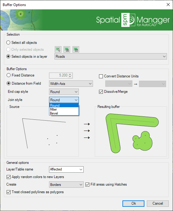
Buffer
Although some application commands allow automatic labeling of object data as part of the process (e.g. when Importing objects), the 'SPMLABEL' command labels data values from tables attached to the objects as Texts
- xxx
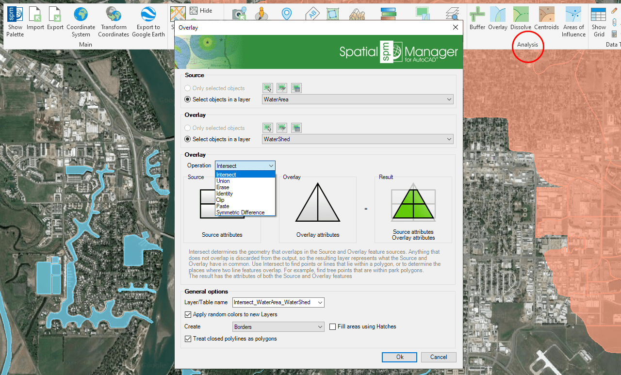
Overlay
Although some application commands allow automatic labeling of object data as part of the process (e.g. when Importing objects), the 'SPMLABEL' command labels data values from tables attached to the objects as Texts
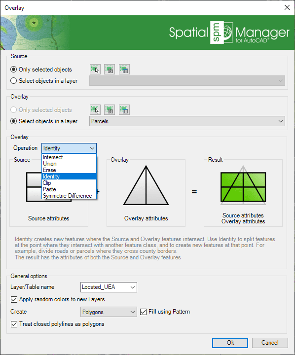
- xxx
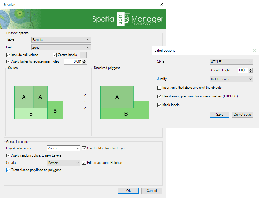
Dissolve
Although some application commands allow automatic labeling of object data as part of the process (e.g. when Importing objects), the 'SPMLABEL' command labels data values from tables attached to the objects as Texts
- xxx
Centroids
Although some application commands allow automatic labeling of object data as part of the process (e.g. when Importing objects), the 'SPMLABEL' command labels data values from tables attached to the objects as Texts
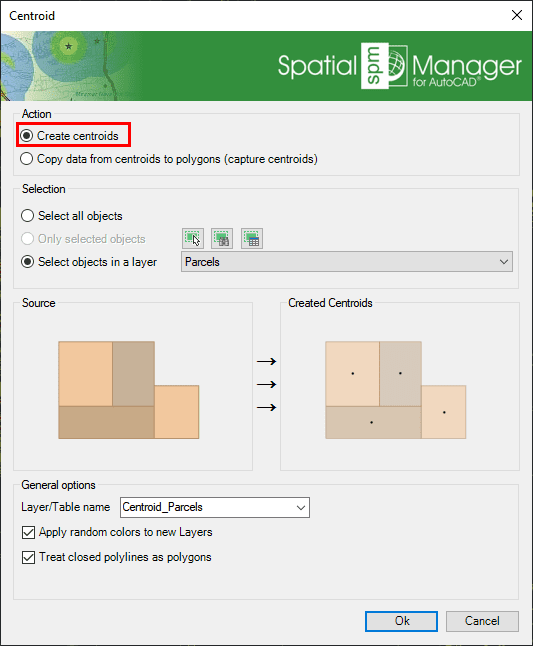
- xxx
Areas of Influence
Although some application commands allow automatic labeling of object data as part of the process (e.g. when Importing objects), the 'SPMLABEL' command labels data values from tables attached to the objects as Texts
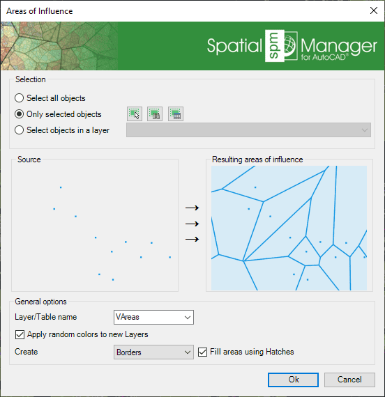
- xxx
Related links
![]()
![]()