Difference between revisions of "Spatial Manager™ for BricsCAD"
m |
m |
||
| (32 intermediate revisions by 2 users not shown) | |||
| Line 1: | Line 1: | ||
| − | [[image:SPM BricsCAD Wiki to Website.png|150px|link= | + | [[image:SPM BricsCAD Wiki to Website.png|150px|link=https://www.spatialmanager.com/spm-forbricscad/ |Spatial Manager™ for BricsCAD product page]] [[image:SPM BricsCAD Wiki to Download.png|150px|link=https://www.spatialmanager.com/download/spatial-manager-bricscad/ |Download Spatial Manager™ for BricsCAD]] |
==Introduction== | ==Introduction== | ||
| − | '''Spatial Manager™ for BricsCAD''' is a powerful BricsCAD plug-in designed for BricsCAD users who need to import, export and manage spatial data in a simple, fast and inexpensive way, which includes many possibilities not seen so far in BricsCAD. It comes in a lightweight application that runs inside BricsCAD and allows the user to import and export geospatial data between BricsCAD drawings and geospatial files, data servers or data stores | + | '''Spatial Manager™ for BricsCAD''' is a powerful BricsCAD plug-in designed for BricsCAD users who need to import, export and manage spatial data in a simple, fast and inexpensive way, which includes many possibilities not seen so far in BricsCAD. It comes in a lightweight application that runs inside BricsCAD and allows the user to import and export geospatial data between BricsCAD drawings and geospatial files, data servers or data stores, manage attached data, display dynamic Background Maps or Street Views, search Locations, create Terrains or Contours, perform GIS analysis operations o selections, etc. |
''Notes:'' | ''Notes:'' | ||
| Line 11: | Line 11: | ||
*''Some components in the images on this page (providers, names, windows look, etc.) may be slightly different from those that will appear on your computer'' | *''Some components in the images on this page (providers, names, windows look, etc.) may be slightly different from those that will appear on your computer'' | ||
*''Some application functions need to access the Internet from the application itself. If you experiment problems in any process, ask your network administrator if there is a Proxy server installed on your network. You can configure the [[Spatial_Manager%E2%84%A2_for_BricsCAD_-_FAQs:_Interface#Options|Proxy settings through the application options]]'' | *''Some application functions need to access the Internet from the application itself. If you experiment problems in any process, ask your network administrator if there is a Proxy server installed on your network. You can configure the [[Spatial_Manager%E2%84%A2_for_BricsCAD_-_FAQs:_Interface#Options|Proxy settings through the application options]]'' | ||
| − | *''IMPORTANT: If you are using the trial version there are a number of limitations that [ | + | *''IMPORTANT: If you are using the trial version there are a number of limitations that [https://wiki.spatialmanager.com/index.php/Spatial_Manager™_for_BricsCAD_-_FAQs:_Licenses#What_is_the_.22Trial_version.22_of_the_application.3F you can review here]'' |
| Line 21: | Line 21: | ||
| − | <span title="Spatial Manager™ for BricsCAD Ribbon (All commands can also be found in the drop-down Menu and Toolbar of Spatial Manager)">[[Image:SpatialManagerforAutoCAD-Ribbon63-2.png | + | <span title="Spatial Manager™ for BricsCAD Ribbon (All commands can also be found in the drop-down Menu and Toolbar of Spatial Manager)">[[Image:SpatialManagerforAutoCAD-Ribbon63-2.png|Spatial Manager™ for BricsCAD Ribbon (All commands can also be found in the drop-down Menu and Toolbar of Spatial Manager)|link=]]</span> |
| Line 28: | Line 28: | ||
*'''Main commands''' | *'''Main commands''' | ||
**'''SPM''': ''Show Palette''. Opens and/or displays the application Palette | **'''SPM''': ''Show Palette''. Opens and/or displays the application Palette | ||
| − | **'''SPMCLOSE''': ''Close''. Closes the | + | **'''SPMCLOSE''': ''Close''. Closes all application Palettes (Main, Data Grid, Street View, etc.). In addition, it redefines the location and size defaults for when they are reopened |
**'''SPMIMPORT''': ''Import''. Directly Imports features from geospatial files or tables without using the application Palette | **'''SPMIMPORT''': ''Import''. Directly Imports features from geospatial files or tables without using the application Palette | ||
***'''-SPMIMPORT [Task name]''': ''Import (Command Line)''. Execute Task(s) from the command line, useful in Scripts, etc. ("Professional" edition only) | ***'''-SPMIMPORT [Task name]''': ''Import (Command Line)''. Execute Task(s) from the command line, useful in Scripts, etc. ("Professional" edition only) | ||
| Line 35: | Line 35: | ||
**'''SPMTRANSFORMCRS''': ''Transform Coordinates''. Creates a new drawing transforming geometrically objects from the current one between two Coordinate Systems | **'''SPMTRANSFORMCRS''': ''Transform Coordinates''. Creates a new drawing transforming geometrically objects from the current one between two Coordinate Systems | ||
**'''SPMCREATEKML''': ''Export to Google Earth''. Exports the current status of the drawing to Google Earth (one click) ("Standard" and "Professional" editions only'') | **'''SPMCREATEKML''': ''Export to Google Earth''. Exports the current status of the drawing to Google Earth (one click) ("Standard" and "Professional" editions only'') | ||
| − | + | *'''Background Maps''' ("Standard" and "Professional" editions only'') | |
| − | *'''Background | ||
**'''SPMBGMAPSHOW''': ''Show''. Shows the selected image Map in the background of the drawing. Includes tools to manage the user Background Maps | **'''SPMBGMAPSHOW''': ''Show''. Shows the selected image Map in the background of the drawing. Includes tools to manage the user Background Maps | ||
**'''SPMBGMAPHIDE''': ''Hide''. Hides the Background Map if it is displayed | **'''SPMBGMAPHIDE''': ''Hide''. Hides the Background Map if it is displayed | ||
| Line 42: | Line 41: | ||
**'''SPMBGMAPIMAGE''': ''Capture''. Creates a BricsCAD raster image corresponding to the display view of the current Background Map (Snapshot) | **'''SPMBGMAPIMAGE''': ''Capture''. Creates a BricsCAD raster image corresponding to the display view of the current Background Map (Snapshot) | ||
**'''SPMBGMAPIMAGEPURGE''': ''Purge''. Delete 'orphan' image tiles and perform some other cleaning operations | **'''SPMBGMAPIMAGEPURGE''': ''Purge''. Delete 'orphan' image tiles and perform some other cleaning operations | ||
| − | *''' | + | *'''Tools''' |
| + | **'''SPMSTREETVIEW''': ''Street View''. Application palette for displaying (and navigate) dynamic Google Street View images on any geo-referenced drawing/map ("Professional" edition only) | ||
| + | **'''SPMSEARCHLOCATION''': ''Search Location''. Search in the drawing for the location of geographical objects (streets, postal addresses, neighborhoods, etc.) based on the text entered ("Professional" edition only'') | ||
| + | **'''SPMLABEL''': ''Entities Labeling''. Texts based on entities data | ||
| + | **'''Selection''' ("Standard" and "Professional" editions only'') | ||
| + | ***'''SPMSPATIALQUERY''': ''Spatial Query''. Advanced entities selection based on geometric and data operations between existing entity groups (Intersect, Touches, Within, Contains, Disjoint, Overlaps or Crosses) | ||
| + | ***'''SPMSELECTBYQUERY''': ''By Query''. Selects entities by a simple or compound query over their data | ||
| + | ***'''SPMSELECTBYTABLE''': ''By Table''. Selects all the entities attached to a specific data table | ||
| + | ***'''SPMZOOMTOSELECTION''': ''Zoom to Selection''. Zoom to the selected entities | ||
| + | *'''Terrains''' ("Professional" edition only) | ||
**'''SPMTERRAIN''': ''Terrain''. Create Terrains, Contours and elevation 3D Points. Command options: | **'''SPMTERRAIN''': ''Terrain''. Create Terrains, Contours and elevation 3D Points. Command options: | ||
***'''1''': 3D Points built by accessing Elevation service providers in any selected area | ***'''1''': 3D Points built by accessing Elevation service providers in any selected area | ||
***'''2''': 2D or 3D Contours from selected 3D Points | ***'''2''': 2D or 3D Contours from selected 3D Points | ||
***'''3''': Terrain wizard. Complete 3D Points, Contours and Terrains funcionality | ***'''3''': Terrain wizard. Complete 3D Points, Contours and Terrains funcionality | ||
| − | *''' | + | *'''GIS Analysis''' ("Professional" edition only) |
| − | **''' | + | **'''SPMBUFFER''': ''Buffers''. Buffered polygons around point entities, linear entities or polygon boundaries |
| − | **''' | + | **'''SPMOVERLAY''': ''Overlays''. New entities based on geometric and data operations between existing entity groups (Intersect, Union, Erase, Identity, Clip, Paste or Symmetric Difference) |
| − | **''' | + | **'''SPMDISSOLVE''': ''Dissolve''. New polygons based on the grouping of other adjacent polygons with some common data |
| − | *'''Data | + | **'''SPMCENTROID''': ''Centroids''. Polygon Centroids creation by adopting the polygons data, or add Centroids data to the polygons that contain them |
| + | **'''SPMINFLUENCEAREAS''': ''Areas of Influence''. Polygons defined by the set of points closest to each point of a selection of points in the drawing (Voronoi diagrams) | ||
| + | *'''Data Tables''' ("Standard" and "Professional" editions only'') | ||
**'''SPMDATATABLEGRID''': ''Data grid''. Opens and displays the 'Data Grid' palette ("Professional" edition only) | **'''SPMDATATABLEGRID''': ''Data grid''. Opens and displays the 'Data Grid' palette ("Professional" edition only) | ||
**'''SPMDATATABLEDEFINE''': ''Define Table''. Defines, restores, modifies, renames or deletes a data table or its fields | **'''SPMDATATABLEDEFINE''': ''Define Table''. Defines, restores, modifies, renames or deletes a data table or its fields | ||
| Line 78: | Line 88: | ||
****Export/Import user Background Maps | ****Export/Import user Background Maps | ||
***Snapshots (geo-referenced BricsCAD Images) of the current Background Map | ***Snapshots (geo-referenced BricsCAD Images) of the current Background Map | ||
| + | **Display and navigate palette for Google Street View | ||
**Terrains | **Terrains | ||
***From 3D Points selected in drawing | ***From 3D Points selected in drawing | ||
| Line 87: | Line 98: | ||
****Contours attached to a Data Table | ****Contours attached to a Data Table | ||
***Generation of three-dimensional Terrain models (using 3D Meshes or some other CAD/BIM objects) | ***Generation of three-dimensional Terrain models (using 3D Meshes or some other CAD/BIM objects) | ||
| − | ***Automatic projection and adjustment of the image of any Background Map (preset or user-configured) over one or more Terrains in the real location | + | ***Automatic projection and adjustment of the image of any Background Map (preset or user-configured) or any Raster image over one or more Terrains in the real location |
**Transformation of coordinates when importing, exporting, showing Background Maps, projecting Background Map images on Terrains, etc. | **Transformation of coordinates when importing, exporting, showing Background Maps, projecting Background Map images on Terrains, etc. | ||
**Transform the drawing Coordinate System | **Transform the drawing Coordinate System | ||
| Line 108: | Line 119: | ||
****Attaching entities to a table | ****Attaching entities to a table | ||
****Detaching entities from their tables | ****Detaching entities from their tables | ||
| − | ***Selecting entities by a simple or compound query over | + | ***Selecting entities by a simple or compound spatial and/or data query over entities geometric relations and/or data |
****Choose or search data from available values in the fields | ****Choose or search data from available values in the fields | ||
***Selecting the entities attached to a table | ***Selecting the entities attached to a table | ||
| − | ***Zoom to the selected entities<br/><br/> | + | ***Zoom to the selected entities |
| + | ***Process GIS analytical operations | ||
| + | ****Buffers | ||
| + | ****Overlays | ||
| + | ****Dissolve | ||
| + | ****Create Centroids or capture Centroids data | ||
| + | ****Areas of influence (Voronoi diagrams) | ||
| + | ***Create Texts from entities data. Optional texts masks<br/><br/> | ||
*'''Import processes''' | *'''Import processes''' | ||
**Entities imported into a new or open drawing | **Entities imported into a new or open drawing | ||
| Line 123: | Line 141: | ||
***Fill properties can be taken from fields values | ***Fill properties can be taken from fields values | ||
**Polygon centroids | **Polygon centroids | ||
| − | **Smart labeling of entities while importing | + | **Smart labeling of entities while importing. Optional label masks |
**Spatial filter to import only the entities in the current view | **Spatial filter to import only the entities in the current view | ||
**Import polygons using "MPolygon" entities | **Import polygons using "MPolygon" entities | ||
| Line 133: | Line 151: | ||
*'''Export processes''' | *'''Export processes''' | ||
**Entities exported to geospatial files or servers | **Entities exported to geospatial files or servers | ||
| + | **Export directly from any data source to any target | ||
**Export (Publish) the current status and style of the drawing to Google Earth (one click) | **Export (Publish) the current status and style of the drawing to Google Earth (one click) | ||
***Raster and vector entities | ***Raster and vector entities | ||
| Line 140: | Line 159: | ||
**Options to export BricsCAD Properties (Handle, Color, Layer, Elevation, etc.) of the entities | **Options to export BricsCAD Properties (Handle, Color, Layer, Elevation, etc.) of the entities | ||
**Options to export the Name and the Attributes of the Block References as well as their Rotation and Scales | **Options to export the Name and the Attributes of the Block References as well as their Rotation and Scales | ||
| − | **Options to export Text entities and their basic properties (Rotation and Height) | + | **Options to export Text entities and their basic properties (Contents, Rotation and Height) |
**Options to export Hatch entities and their properties (Name, Angle, Scale, etc.) | **Options to export Hatch entities and their properties (Name, Angle, Scale, etc.) | ||
**Options to export the X/Y/Z coordinates, Length and Area of the entities | **Options to export the X/Y/Z coordinates, Length and Area of the entities | ||
| Line 157: | Line 176: | ||
*''Notes:'' | *''Notes:'' | ||
| + | **''GIS analysis functionality is only available in the 'Professional' edition'' | ||
| + | **'''Street View' functionality is only available in the 'Professional' edition'' | ||
**''Transforming the Coordinate System of the objects in a drawing functionality is only available in the 'Professional' edition'' | **''Transforming the Coordinate System of the objects in a drawing functionality is only available in the 'Professional' edition'' | ||
**''Terrains and related objects functionality is only available in the 'Professional' edition'' | **''Terrains and related objects functionality is only available in the 'Professional' edition'' | ||
| Line 164: | Line 185: | ||
**'''Background maps' functionality is available in the 'Standard' and 'Professional' editions only'' | **'''Background maps' functionality is available in the 'Standard' and 'Professional' editions only'' | ||
**''Full export functionality (SPMEXPORT) is only found in the 'Professional' edition, although the functionality to export the current status of the drawing to Google Earth (SPMCREATEKML) is also available in the 'Standard' edition'' | **''Full export functionality (SPMEXPORT) is only found in the 'Professional' edition, although the functionality to export the current status of the drawing to Google Earth (SPMCREATEKML) is also available in the 'Standard' edition'' | ||
| − | **''The Tasks technology is available in the | + | **''The Tasks technology is available in the 'Professional' edition only'' |
| Line 173: | Line 194: | ||
'''IMPORT video''' updated on May 2018 | '''IMPORT video''' updated on May 2018 | ||
| − | *[ | + | *[https://youtu.be/sOfDVtCinnk?rel=0 Importing Shapefiles (SHP)] |
To experiment the '''EXPORT capabilities''' (on the 'Professional' edition), please watch the following videos: | To experiment the '''EXPORT capabilities''' (on the 'Professional' edition), please watch the following videos: | ||
| − | *[ | + | *[https://youtu.be/MCsdcmdNo1M?rel=0 Directly to Google Earth (KML) from your drawing] |
| − | *[ | + | *[https://youtu.be/O6PoducEeKA?rel=0 Coordinates to Excel from your drawing] |
| − | *[ | + | *[https://youtu.be/KpJqHzl5WOM?rel=0 Import a Shapefile and export it as 3D Google Earth] |
| − | *[ | + | *[https://youtu.be/n-NN2X9Ix7k?rel=0 OpenStreetMap data. Edit and export to Google Earth] |
| − | *[ | + | *[https://youtu.be/2Sj_fkYJaMs?rel=0 Import a Shapefile. Edit & export as Shapefile] |
| − | *[ | + | *[https://youtu.be/PM05LrwVQ8w?rel=0 Export improvements] |
| − | *[ | + | *[https://youtu.be/_fIViJ70Be8?rel=0 Publish the drawing to Google Earth] (on the 'Standard' and 'Professional' editions) |
To know how to '''BATCH IMPORT works''', please watch this video: | To know how to '''BATCH IMPORT works''', please watch this video: | ||
| − | *[ | + | *[https://youtu.be/EBTMDdKBmVc?rel=0 ‘Import all’ from a folder] |
To take a look at the '''TASKS technology''' (on the 'Professional' edition), please watch this video: | To take a look at the '''TASKS technology''' (on the 'Professional' edition), please watch this video: | ||
| − | *[ | + | *[https://youtu.be/uLFDuJ_8qUM?rel=0 Tasks preview] |
To learn how is working the '''DIRECT DATA EDITION''' and how to '''MANAGE the DATA STRUCTURE''' (on the 'Standard' and 'Professional' editions), please watch the following videos: | To learn how is working the '''DIRECT DATA EDITION''' and how to '''MANAGE the DATA STRUCTURE''' (on the 'Standard' and 'Professional' editions), please watch the following videos: | ||
| − | *[ | + | *[https://youtu.be/P2ch94Egulk?rel=0 Direct Data Edition] |
| − | *[ | + | *[https://youtu.be/Ud_4ZM7gWS4?rel=0 Managing the Data Structure] |
| − | *[ | + | *[https://youtu.be/i9-PqDRcKy4?rel=0 Selecting objects by simple or compound queries] |
To know more about the attractive and useful dynamic '''BACKGROUND MAPS''' (on the 'Standard' and 'Professional' editions), please watch the following videos: | To know more about the attractive and useful dynamic '''BACKGROUND MAPS''' (on the 'Standard' and 'Professional' editions), please watch the following videos: | ||
| − | *[ | + | *[https://youtu.be/GZl7aKy57kE?rel=0 Background Maps 1] |
| − | *[ | + | *[https://youtu.be/Dww6hoACliw?rel=0 Background Maps 2] |
| − | *[ | + | *[https://youtu.be/UQ1N0A06tH4?rel=0 Background Map Snapshots] |
To know how to '''LABEL the entities WHILE IMPORTING''', please watch the following videos: | To know how to '''LABEL the entities WHILE IMPORTING''', please watch the following videos: | ||
| − | *[ | + | *[https://youtu.be/J6mhPqiBgTQ?rel=0 Labeling entities] |
| − | *[ | + | *[https://youtu.be/JoI9XeU6Yho?rel=0 Labels also for linear elements] |
To know how to '''Use the BLOCKS WHEN IMPORTING''', please watch this video: | To know how to '''Use the BLOCKS WHEN IMPORTING''', please watch this video: | ||
| − | *[ | + | *[https://youtu.be/XJJBr8JKz_0?rel=0 'Blocks' enhancements] |
To know how to '''Create elevation 3D Points, Contours or Terrains''', please watch this video: | To know how to '''Create elevation 3D Points, Contours or Terrains''', please watch this video: | ||
| − | *[ | + | *[https://youtu.be/Gif9O_nND2U?rel=0 Terrains] |
| Line 236: | Line 257: | ||
*[[Spatial Manager™ for BricsCAD - FAQs: Import | Import processes, parameters, coordinate transformation, extended data, tasks]] | *[[Spatial Manager™ for BricsCAD - FAQs: Import | Import processes, parameters, coordinate transformation, extended data, tasks]] | ||
*[[Spatial Manager™ for BricsCAD - FAQs: Export ("Professional" edition only) | Export processes, parameters, coordinate transformation, export to Google Earth, extended data]] ("Professional" edition only, except "Export to Google Earth" on "Standard" and "Professional" editions) | *[[Spatial Manager™ for BricsCAD - FAQs: Export ("Professional" edition only) | Export processes, parameters, coordinate transformation, export to Google Earth, extended data]] ("Professional" edition only, except "Export to Google Earth" on "Standard" and "Professional" editions) | ||
| − | *[[Spatial Manager™ for BricsCAD - FAQs: Data Structure Management ("Standard" and "Professional" editions only) | Create or edit data tables, attach, detach or select entities]] ("Standard" and "Professional" editions only'') | + | *[[Spatial Manager™ for BricsCAD - FAQs: Data Structure Management ("Standard" and "Professional" editions only) | Create or edit data tables, attach, detach, label or select entities]] ("Standard" and "Professional" editions only'') |
| + | *[[Spatial Manager™ for BricsCAD - FAQs: Advanced Selection ("Standard" and "Professional" editions only) | Select by data Table, data Query or Spatial Query]] ("Standard" and "Professional" editions only'') | ||
| + | *[[Spatial Manager™ for BricsCAD - FAQs: GIS Analysis ("Professional" edition only) | Buffers, Overlays, Dissolutions, Centroids, Areas of Influence ]] ("Professional" edition only'') | ||
*[[Spatial Manager™ for BricsCAD - FAQs: Transform drawings Coordinate System ("Professional" edition only) | Transform the drawing between two Coordinate Systems]] ("Professional" edition only'') | *[[Spatial Manager™ for BricsCAD - FAQs: Transform drawings Coordinate System ("Professional" edition only) | Transform the drawing between two Coordinate Systems]] ("Professional" edition only'') | ||
*[[Spatial Manager™ for BricsCAD - FAQs: Background Maps ("Standard" and "Professional" editions only) | Use dynamic Background image Maps, reference Maps]] ("Standard" and "Professional" editions only'') | *[[Spatial Manager™ for BricsCAD - FAQs: Background Maps ("Standard" and "Professional" editions only) | Use dynamic Background image Maps, reference Maps]] ("Standard" and "Professional" editions only'') | ||
*[[Spatial Manager™ for BricsCAD - FAQs: Terrains ("Professional" edition only) | Create elevation 3D Points, 2D or 3D Contours or Terrain 3D models]] ("Professional" edition only'') | *[[Spatial Manager™ for BricsCAD - FAQs: Terrains ("Professional" edition only) | Create elevation 3D Points, 2D or 3D Contours or Terrain 3D models]] ("Professional" edition only'') | ||
*[[Spatial Manager™ for BricsCAD - FAQs: Search Location ("Professional" edition only) | Search for Locations of geographical objects in the drawing]] ("Professional" edition only'') | *[[Spatial Manager™ for BricsCAD - FAQs: Search Location ("Professional" edition only) | Search for Locations of geographical objects in the drawing]] ("Professional" edition only'') | ||
| + | *[[Spatial Manager™ for BricsCAD - FAQs: Street View ("Professional" edition only) | Drawing Street View display and navigation]] ("Professional" edition only'') | ||
*[[Spatial Manager™ for BricsCAD - FAQs: Application Programming Interface (API) ("Professional" edition only) | Application Programming Interface (API)]] ("Professional" edition only'') | *[[Spatial Manager™ for BricsCAD - FAQs: Application Programming Interface (API) ("Professional" edition only) | Application Programming Interface (API)]] ("Professional" edition only'') | ||
| − | *[ | + | *[https://www.spatialmanager.com/use-spatial-manager-wiki/ How to use the Spatial Manager Wiki? (Blog)] |
| Line 254: | Line 278: | ||
*[[Coordinate Systems objects list | Coordinate Systems objects list]] | *[[Coordinate Systems objects list | Coordinate Systems objects list]] | ||
*[[Spatial Manager™ for BricsCAD EULA | End User License Agreement]] | *[[Spatial Manager™ for BricsCAD EULA | End User License Agreement]] | ||
| − | *[ | + | *[https://www.spatialmanager.com Spatial Manager™ web] |
| − | [[image:SPM BricsCAD Wiki to Website.png|150px|link= | + | [[image:SPM BricsCAD Wiki to Website.png|150px|link=https://www.spatialmanager.com/spm-forbricscad/ |Spatial Manager™ for BricsCAD product page]] [[image:SPM BricsCAD Wiki to Download.png|150px|link=https://www.spatialmanager.com/download/spatial-manager-bricscad/ |Download Spatial Manager™ for BricsCAD]] |
Revision as of 17:55, 2 August 2021
![]()
![]()
Introduction
Spatial Manager™ for BricsCAD is a powerful BricsCAD plug-in designed for BricsCAD users who need to import, export and manage spatial data in a simple, fast and inexpensive way, which includes many possibilities not seen so far in BricsCAD. It comes in a lightweight application that runs inside BricsCAD and allows the user to import and export geospatial data between BricsCAD drawings and geospatial files, data servers or data stores, manage attached data, display dynamic Background Maps or Street Views, search Locations, create Terrains or Contours, perform GIS analysis operations o selections, etc.
Notes:
- Some functions or options may not be available in older versions. Please review the instructions and notes in each FAQs section because they describe the functional limitations for these versions
- Some components in the images on this page (providers, names, windows look, etc.) may be slightly different from those that will appear on your computer
- Some application functions need to access the Internet from the application itself. If you experiment problems in any process, ask your network administrator if there is a Proxy server installed on your network. You can configure the Proxy settings through the application options
- IMPORTANT: If you are using the trial version there are a number of limitations that you can review here
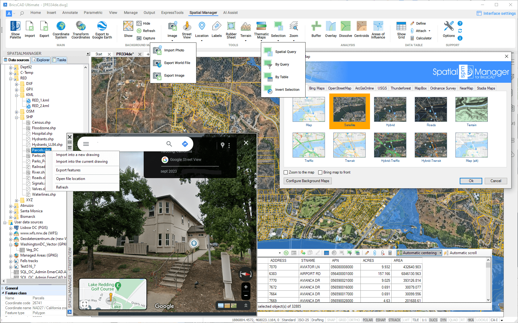
BricsCAD commands
")
This is the list of BricsCAD commands included in Spatial Manager™ for BricsCAD
- Main commands
- SPM: Show Palette. Opens and/or displays the application Palette
- SPMCLOSE: Close. Closes all application Palettes (Main, Data Grid, Street View, etc.). In addition, it redefines the location and size defaults for when they are reopened
- SPMIMPORT: Import. Directly Imports features from geospatial files or tables without using the application Palette
- -SPMIMPORT [Task name]: Import (Command Line). Execute Task(s) from the command line, useful in Scripts, etc. ("Professional" edition only)
- SPMEXPORT: Export. Exports BricsCAD entities into geospatial files or tables ("Professional" edition only)
- SPMSETCRS: Coordinate system. Sets the Coordinate Reference System (CRS) for the drawing
- SPMTRANSFORMCRS: Transform Coordinates. Creates a new drawing transforming geometrically objects from the current one between two Coordinate Systems
- SPMCREATEKML: Export to Google Earth. Exports the current status of the drawing to Google Earth (one click) ("Standard" and "Professional" editions only)
- Background Maps ("Standard" and "Professional" editions only)
- SPMBGMAPSHOW: Show. Shows the selected image Map in the background of the drawing. Includes tools to manage the user Background Maps
- SPMBGMAPHIDE: Hide. Hides the Background Map if it is displayed
- SPMBGMAPREFRESH: Refresh. Regenerates the image of the Background Map, which may be needed under certain graphic situations
- SPMBGMAPIMAGE: Capture. Creates a BricsCAD raster image corresponding to the display view of the current Background Map (Snapshot)
- SPMBGMAPIMAGEPURGE: Purge. Delete 'orphan' image tiles and perform some other cleaning operations
- Tools
- SPMSTREETVIEW: Street View. Application palette for displaying (and navigate) dynamic Google Street View images on any geo-referenced drawing/map ("Professional" edition only)
- SPMSEARCHLOCATION: Search Location. Search in the drawing for the location of geographical objects (streets, postal addresses, neighborhoods, etc.) based on the text entered ("Professional" edition only)
- SPMLABEL: Entities Labeling. Texts based on entities data
- Selection ("Standard" and "Professional" editions only)
- SPMSPATIALQUERY: Spatial Query. Advanced entities selection based on geometric and data operations between existing entity groups (Intersect, Touches, Within, Contains, Disjoint, Overlaps or Crosses)
- SPMSELECTBYQUERY: By Query. Selects entities by a simple or compound query over their data
- SPMSELECTBYTABLE: By Table. Selects all the entities attached to a specific data table
- SPMZOOMTOSELECTION: Zoom to Selection. Zoom to the selected entities
- Terrains ("Professional" edition only)
- SPMTERRAIN: Terrain. Create Terrains, Contours and elevation 3D Points. Command options:
- 1: 3D Points built by accessing Elevation service providers in any selected area
- 2: 2D or 3D Contours from selected 3D Points
- 3: Terrain wizard. Complete 3D Points, Contours and Terrains funcionality
- SPMTERRAIN: Terrain. Create Terrains, Contours and elevation 3D Points. Command options:
- GIS Analysis ("Professional" edition only)
- SPMBUFFER: Buffers. Buffered polygons around point entities, linear entities or polygon boundaries
- SPMOVERLAY: Overlays. New entities based on geometric and data operations between existing entity groups (Intersect, Union, Erase, Identity, Clip, Paste or Symmetric Difference)
- SPMDISSOLVE: Dissolve. New polygons based on the grouping of other adjacent polygons with some common data
- SPMCENTROID: Centroids. Polygon Centroids creation by adopting the polygons data, or add Centroids data to the polygons that contain them
- SPMINFLUENCEAREAS: Areas of Influence. Polygons defined by the set of points closest to each point of a selection of points in the drawing (Voronoi diagrams)
- Data Tables ("Standard" and "Professional" editions only)
- SPMDATATABLEGRID: Data grid. Opens and displays the 'Data Grid' palette ("Professional" edition only)
- SPMDATATABLEDEFINE: Define Table. Defines, restores, modifies, renames or deletes a data table or its fields
- SPMDATATABLEATTACH: Attach. Attaches one or more entities to a data table
- SPMDATATABLEDETACH: Detach. Detaches one or more entities from their corresponding attached data table
- Support commands
- SPMOPTIONS: Options. Set of parameters to configure the application (includes also the functionality of SPMUPDATE and SPMABOUT)
- SPMHELP: Help. Shows the application help (Wiki format)
- SPMUPDATE: Updates. Checks if there is a new application release to be downloaded from Internet
- SPMABOUT: Information. Shows basic information about the application and the installed release
Note: All the command names are also valid if you replace the prefix "SPM" for "SPATIALMANAGER". For example, "SPATIALMANAGERCREATEKML" is equivalent to "SPMCREATEKML", or "SPATIALMANAGER" is equivalent to "SPM"
Main features
- General
- Import/export spatial data into/from BricsCAD drawings
- Publish to Google Earth
- Search the location of geographic objects
- Dynamic Background image Maps from Google Maps, Bing, OpenStreeMap, Mapbox, Ordnance Survey, NearMap, etc.
- Configurable user Maps
- XYZ / TMS, WMTS and WMS compatible
- WMS multi-layer maps
- Export/Import user Background Maps
- Snapshots (geo-referenced BricsCAD Images) of the current Background Map
- Configurable user Maps
- Display and navigate palette for Google Street View
- Terrains
- From 3D Points selected in drawing
- From a grid of 3D Points built by accessing Elevation service providers in any selected area
- 2D or 3D Contours
- Minor and major Contours
- Contour labels. Optional label masks
- Layer Separation and different color models
- Contours attached to a Data Table
- Generation of three-dimensional Terrain models (using 3D Meshes or some other CAD/BIM objects)
- Automatic projection and adjustment of the image of any Background Map (preset or user-configured) or any Raster image over one or more Terrains in the real location
- Transformation of coordinates when importing, exporting, showing Background Maps, projecting Background Map images on Terrains, etc.
- Transform the drawing Coordinate System
- XDATA / Extended Entity Data (EED)
- Data grid palette interactive and synchronized
- Selecting entities and navigation tools in the grid
- Editing data and columns
- Columns sorting
- Sorting data by column
- Automatic column width adjustment
- Direct export to CSV, TXT, etc.
- Multi-table grid
- Viewer palette
- Also shows some other data as the Blocks properties (Name and Attributes), Layer, geometric properties, etc.
- Edit values directly in the palette
- Hyperlinks
- Managing data structure
- Define, modify, rename and delete tables and fields
- Recover data table structures from the drawing entities
- Attaching entities to a table
- Detaching entities from their tables
- Selecting entities by a simple or compound spatial and/or data query over entities geometric relations and/or data
- Choose or search data from available values in the fields
- Selecting the entities attached to a table
- Zoom to the selected entities
- Process GIS analytical operations
- Buffers
- Overlays
- Dissolve
- Create Centroids or capture Centroids data
- Areas of influence (Voronoi diagrams)
- Create Texts from entities data. Optional texts masks
- Data grid palette interactive and synchronized
- Import processes
- Entities imported into a new or open drawing
- Raster and vector entities
- Smart Batch import
- Basic target layer or new target layers using a field value
- Use blocks for points and centroids
- Select the name of the Block according to the value of a field
- Block insertion parameters from field values
- Polygon fills and transparencies
- Fill properties can be taken from fields values
- Polygon centroids
- Smart labeling of entities while importing. Optional label masks
- Spatial filter to import only the entities in the current view
- Import polygons using "MPolygon" entities
- Elevation and thickness from field values
- Import data from tables as XDATA / Extended Entity Data (EED)
- Speed up the processes skipping some wizard steps
- Use the intuitive palette options or the quick import function
- Save Tasks to replay the import processes so many times as desired
- Export processes
- Entities exported to geospatial files or servers
- Export directly from any data source to any target
- Export (Publish) the current status and style of the drawing to Google Earth (one click)
- Raster and vector entities
- Select the entities to be exported
- Option to export also the data of the entities and choose it from what Table and Fields
- Option to treat the closed polylines as polygons
- Options to export BricsCAD Properties (Handle, Color, Layer, Elevation, etc.) of the entities
- Options to export the Name and the Attributes of the Block References as well as their Rotation and Scales
- Options to export Text entities and their basic properties (Contents, Rotation and Height)
- Options to export Hatch entities and their properties (Name, Angle, Scale, etc.)
- Options to export the X/Y/Z coordinates, Length and Area of the entities
- Automatic complex geometric operations
- Filtering of incompatible entities
- Option to open the exported file location directly
- Data sources
- Manage your own shortcuts
- Access to spatial data files (SHP, GPX, KML/KMZ, OSM, PBF, LAS/LAZ, GPKG, CSV, TXT, ASC, XYZ, MIF/MID, TAB, E00, SQLite, SDF, GML, XML, JPF, PNG, TIF, etc.)
- Manage your User Data Sources
- Access to spatial database servers (SQL Server, PostGIS, etc.)
- Views and Tables
- Access to other connections (WFS, ODBC points or WKB - Excel, Access, dBase,...-, etc.)
- See current available Data Providers
- Notes:
- GIS analysis functionality is only available in the 'Professional' edition
- 'Street View' functionality is only available in the 'Professional' edition
- Transforming the Coordinate System of the objects in a drawing functionality is only available in the 'Professional' edition
- Terrains and related objects functionality is only available in the 'Professional' edition
- 'Search Location' functionality is only available in the 'Professional' edition
- Data management (Structures, Queries, Direct editing, etc.) based on XDATA / Extended Entity Data (EED) is only available in the 'Standard' and 'Professional' editions
- Data grid is only available in the 'Professional' edition, although the overall data management (Structures, Queries, Direct editing, etc.) is also available in the 'Standard' edition
- 'Background maps' functionality is available in the 'Standard' and 'Professional' editions only
- Full export functionality (SPMEXPORT) is only found in the 'Professional' edition, although the functionality to export the current status of the drawing to Google Earth (SPMCREATEKML) is also available in the 'Standard' edition
- The Tasks technology is available in the 'Professional' edition only
To get a first preview of the application, please watch this video:
IMPORT video updated on May 2018
To experiment the EXPORT capabilities (on the 'Professional' edition), please watch the following videos:
- Directly to Google Earth (KML) from your drawing
- Coordinates to Excel from your drawing
- Import a Shapefile and export it as 3D Google Earth
- OpenStreetMap data. Edit and export to Google Earth
- Import a Shapefile. Edit & export as Shapefile
- Export improvements
- Publish the drawing to Google Earth (on the 'Standard' and 'Professional' editions)
To know how to BATCH IMPORT works, please watch this video:
To take a look at the TASKS technology (on the 'Professional' edition), please watch this video:
To learn how is working the DIRECT DATA EDITION and how to MANAGE the DATA STRUCTURE (on the 'Standard' and 'Professional' editions), please watch the following videos:
To know more about the attractive and useful dynamic BACKGROUND MAPS (on the 'Standard' and 'Professional' editions), please watch the following videos:
To know how to LABEL the entities WHILE IMPORTING, please watch the following videos:
To know how to Use the BLOCKS WHEN IMPORTING, please watch this video:
To know how to Create elevation 3D Points, Contours or Terrains, please watch this video:
FAQs
Here you will find all the technical information available on the implementation as well as tutorials, additional data, etc.
- How to Start?
- Licenses, activation, support, updates, purchasing options
- Current compatible BricsCAD applications
- Application Data Providers
- Interface, Wizards, Options, Configurations
- Data sources, Shortcuts, User Data Sources
- Spatial files
- Databases, Data stores
- Import processes, parameters, coordinate transformation, extended data, tasks
- Export processes, parameters, coordinate transformation, export to Google Earth, extended data ("Professional" edition only, except "Export to Google Earth" on "Standard" and "Professional" editions)
- Create or edit data tables, attach, detach, label or select entities ("Standard" and "Professional" editions only)
- Select by data Table, data Query or Spatial Query ("Standard" and "Professional" editions only)
- Buffers, Overlays, Dissolutions, Centroids, Areas of Influence ("Professional" edition only)
- Transform the drawing between two Coordinate Systems ("Professional" edition only)
- Use dynamic Background image Maps, reference Maps ("Standard" and "Professional" editions only)
- Create elevation 3D Points, 2D or 3D Contours or Terrain 3D models ("Professional" edition only)
- Search for Locations of geographical objects in the drawing ("Professional" edition only)
- Drawing Street View display and navigation ("Professional" edition only)
- Application Programming Interface (API) ("Professional" edition only)
Links
Here you will find some useful links to other pages of Spatial Manager™ for BricsCAD
![]()
![]()