Difference between revisions of "Spatial Manager™ for GstarCAD - FAQs: Advanced Selection ("Standard" and "Professional" editions only)"
m |
m |
||
| (11 intermediate revisions by the same user not shown) | |||
| Line 11: | Line 11: | ||
===Introduction=== | ===Introduction=== | ||
*'''Objective of this section''' | *'''Objective of this section''' | ||
| − | **To learn how to | + | **To learn how to select GstarCAD entities in a Data and/or Geometric relationship basis |
*'''Topics in this section''' | *'''Topics in this section''' | ||
| − | + | **Select entities based on data queries | |
| − | + | **Select entities which are attached to a specific table | |
| − | + | **Select entities based on spatial queries | |
| − | |||
| − | |||
| − | **Select entities based on | ||
| − | **Select entities | ||
**Zoom to the selection | **Zoom to the selection | ||
| − | *''''' | + | *'''''NOTES:''''' |
| − | *''''' | + | **'''''Entities Data''': You can learn more about Tables and attached Data in the [[Spatial Manager™ for GstarCAD - FAQs: Data Structure Management ("Standard" and "Professional" editions only) | Data Structure Management]] chapter'' |
| − | + | **'''''Selections performance''': The selection of entities in GstarCAD may be a few slower when the "SpatialManager" palette is open, depending on the data of the entities'' | |
| − | + | **'''''Complex and mixed selections''': In addition to the use of the below commands or in combination with them, you can make use of selecting entities in the [[Spatial_Manager%E2%84%A2_for_GstarCAD_-_FAQs:_Data_Structure_Management_(%22Standard%22_and_%22Professional%22_editions_only)#Can_I_view_and_edit_the_entities_data_in_a_table_form.3F_.28.22Professional.22_edition_only.29|Data Grid]] or by using any other selection method available in GstarCAD (Quick Select, etc.). Also note that, as most of the advanced application or GstarCAD selection commands will let you apply the selection to the current selection, the number of possible combinations to select what you are interested in is almost unlimited'' | |
| − | |||
| − | |||
| − | |||
| − | |||
| − | |||
| − | |||
| − | |||
| − | |||
| − | |||
| − | |||
| − | '' | ||
| − | |||
| − | |||
| − | |||
| − | |||
| − | |||
| − | |||
| − | |||
| − | |||
| − | |||
| − | |||
| − | |||
| − | |||
| − | |||
| − | |||
| − | |||
| − | |||
| − | |||
| − | |||
| − | |||
| − | |||
| − | |||
| − | |||
| − | |||
| − | |||
| − | |||
| − | |||
| − | |||
| − | |||
| − | |||
| − | |||
| − | |||
| − | |||
| − | |||
| − | |||
| − | |||
| − | |||
| − | |||
| − | |||
| − | |||
| − | |||
| − | |||
| − | |||
| − | |||
| − | |||
| − | |||
| − | |||
| − | |||
| − | |||
| − | |||
| − | |||
| − | |||
| − | |||
| − | |||
| − | |||
| − | |||
| − | |||
| − | |||
| − | |||
| − | |||
| − | |||
| − | |||
| − | |||
| − | |||
| − | |||
| − | |||
| − | |||
| − | |||
| − | |||
| − | |||
| − | |||
===Can I define a selection of entities based on the values of their data?=== | ===Can I define a selection of entities based on the values of their data?=== | ||
| − | The command 'SPMSELECTBYQUERY' in 'Spatial Manager™ for GstarCAD' allows you select entities in the drawing according to the result of | + | The command 'SPMSELECTBYQUERY' in 'Spatial Manager™ for GstarCAD' allows you select entities in the drawing according to the result of simple or compound data queries |
| Line 137: | Line 52: | ||
| − | You can use the command 'SPMZOOMTOSELECTION' (see below) to quickly zoom | + | ''Note: You can use the command 'SPMZOOMTOSELECTION' (see below) to quickly zoom to the selection extent'' |
| Line 154: | Line 69: | ||
| − | ''Note: You can use the command 'SPMZOOMTOSELECTION' (see below) to quickly zoom to the selection extent'' | + | ''Note: You can use the command 'SPMZOOMTOSELECTION' (see below) to quickly zoom to the selection extent'' |
| + | |||
| + | |||
| + | ===Can I define a selection of entities based on their geometric relationship?=== | ||
| + | The command 'SPMSPATIALQUERY' in 'Spatial Manager™ for GstarCAD' allows you select entities in the drawing according to the result of advanced simple or compound spatial queries | ||
| − | = | + | <span title="'SPMSPATIALQUERY' command in the Spatial Manager™ for GstarCAD ribbon">[[Image:SPMSpatialQuery.png|'SPMSPATIALQUERY' command in the Spatial Manager™ for GstarCAD ribbon|link=]]</span> |
| − | |||
| − | + | [[image:SPMSpatialQueryGCAD.png|border|900px|Advanced selection by processing Spatial Queries|link={{filepath:SPMSpatialQueryGCAD.png}}]] | |
| − | + | ''Advanced selection by processing Spatial Queries'' | |
| − | + | <span title="Spatial Query parameters window">[[image:SPMSpatialQueryGCADWin.png|border|link=]]</span> | |
| + | This function allows you to select entities in the drawing by performing "geometric operations" between two groups of entities: "Selection" (Group 1) and "Query with" (Group 2). For example, according to the chosen parameters in this image, all the Hydrants (points) that are located within a Parcel (polygons) would be selected | ||
| − | |||
| − | |||
| + | *'''Parameters and options''' | ||
| + | **Entities selection (Group 1 and Group 2) | ||
| + | ***''Only selected entities'': A set of entities will be selected. You can select the entities before executing this command (for one of the Groups) or by using the Selecting buttons in this window | ||
| + | ****Manual selection | ||
| + | ****Select by Query: Select entities according to the result of a simplex or compound data query [[#Can_I_define_a_selection_of_entities_based_on_the_values_of_their_data.3F|''(See "Selecting by Query")'']] | ||
| + | ****Select by Table: Select entities which have been previously attached to a specific data table [[#Can_I_select_all_the_entities_attached_to_the_same_data_table.3F|''(See "Selecting by Table")'']] | ||
| + | ***''Select entities in a layer'': All the entities in a GstarCAD Layer will be selected. You can select the layer using the drop-down list in this window | ||
| + | **Spatial operation | ||
| + | ***''Intersects'': A geometry Intersects another one if they have at least a point in common. It is the opposite of 'Disjoint'. For example, combined with [[Spatial_Manager%E2%84%A2_for_GstarCAD_-_FAQs:_GIS_Analysis_(%22Professional%22_edition_only)#Buffer|''Buffers'']], entities that are located at a certain distance from other entities, which will normally be points or linear entities (such as buildings located at a certain distance from road or street axes, etc.) | ||
| + | ***''Touches'': A geometry Touches another one if they have common points only at their boundaries, without intersection and no one of them contains or is equal to the other. For example, buildings touching another building within a block of contiguous buildings (the drawing must be very precise because no intersections should occur) | ||
| + | ***''Within'': A geometry is Within another one if it is completely inside or they are equal. It is the inverse of 'Contains'. For example, to select points representing pharmacies within a neighborhood, polygons representing hospitals within a municipality or buildings within a parcel, etc. | ||
| + | ***''Contains'': A geometry Contains another one if the second one is completely inside of the first one or they are equal. Is is the inverse of 'Within'. For example, to select all the parcels in a municipality that contain one or more buildings | ||
| + | ***''Disjoint'': A geometry is Disjoint from another one if they do not have any points in common (that is, "out of": It does not intersect and does not touch). It is the opposite of 'Intersects' | ||
| + | ***''Overlaps'': A geometry Overlaps another one if they have areas in common, but no one of them is fully inside the other one and they are not equal. For example, polygons that intersect, but none of them are completely inside each other, i.e., " they cross". A practical case could be the selection of buildings in one municipality that are located partially within the boundary of the municipality and partially within the boundary of another adjacent municipality | ||
| + | ***''Crosses'': A geometry (linear entitiy) Crosses another one if it has at the same time parts inside and outside of the second one. For example, to select road sections that are partially located within the boundaries of two or more municipalities | ||
| − | |||
| + | ''Note: You can use the command 'SPMZOOMTOSELECTION' (see below) to quickly zoom to the selection extent'' | ||
| − | |||
| − | + | ===Is there any way to locate on the screen all the selected entities?=== | |
| + | Yes, the 'Spatial Manager™ for GstarCAD' 'SPMZOOMTOSELECTION' command, zooms to the current selection extent so you can locate all the selected entities in an optimal size view | ||
| − | + | <span title="'SPMZOOMTOSELECTION' command in the Spatial Manager™ for GstarCAD Ribbon (Can also be found in the drop-down Menu and Toolbar of Spatial Manager)">[[Image:SpatialManagerforBricsCAD-ZoomSelection.png|'SPMZOOMTOSELECTION' command in the Spatial Manager™ for GstarCAD Ribbon (Can also be found in the drop-down Menu and Toolbar of Spatial Manager)|link=]]</span> | |
| − | |||
| − | |||
| − | |||
| − | |||
| − | |||
| − | |||
| − | |||
| − | |||
| − | |||
| − | |||
| − | |||
| − | |||
| − | |||
| − | |||
| − | |||
| − | |||
| − | |||
| − | |||
| − | |||
| − | |||
| − | |||
| − | |||
| − | |||
| − | |||
| − | |||
| − | |||
| − | |||
| − | |||
| − | |||
| − | <span title=" | + | <span title="Zoom to the current selection extent">[[Image:ZoomToSelection.png|border|Zoom to the current selection extent|link=]]</span> |
| − | + | ''Note: This functionality can be very handy as a complement to the previous selection commands, but also if it is used with other GstarCAD selection functions'' | |
| − | |||
| − | |||
| − | |||
| − | |||
| − | |||
| − | |||
| − | |||
| − | |||
| − | |||
| − | |||
| − | |||
| − | |||
| − | |||
==Related links== | ==Related links== | ||
| − | *[https://www.spatialmanager.com/combine-quick-select-and-select-by-query/ Combine Quick select and Select by Query] | + | *Blog posts |
| − | *''Developed for other CAD applications prior to the release of Spatial Manager™ for GstarCAD but also applicable'' | + | **[https://www.spatialmanager.com/combine-quick-select-and-select-by-query/ Combine Quick select and Select by Query] |
| − | **[https://www.spatialmanager.com/select-by-query-in-autocad-and-bricscad/ Select by query in GstarCAD] | + | **[https://www.spatialmanager.com/locating-polygons-crossed-by-specific-linear-objects/ Locating polygons crossed by specific linear entities] |
| − | **[https://www.spatialmanager.com/retrieve-existing-data-values-when-querying/ Retrieve existing data values when querying] | + | **''Developed for other CAD applications prior to the release of Spatial Manager™ for GstarCAD but also applicable'' |
| − | **[https://www.spatialmanager.com/analysis-of-parcels-crossed-by-a-road/ Analysis of parcels crossed by a road] | + | ***[https://www.spatialmanager.com/select-by-query-in-autocad-and-bricscad/ Select by query in GstarCAD] |
| + | ***[https://www.spatialmanager.com/retrieve-existing-data-values-when-querying/ Retrieve existing data values when querying] | ||
| + | ***[https://www.spatialmanager.com/analysis-of-parcels-crossed-by-a-road/ Analysis of parcels crossed by a road] | ||
Revision as of 01:28, 25 August 2021
![]()
![]()
Notes:
- Some components in the images on this page (providers, names, windows look, etc.) may be slightly different from those that will appear on your computer
- Some application functions need to access the Internet from the application itself. If you experiment problems in any process, ask your network administrator if there is a Proxy server installed on your network. You can configure the Proxy settings through the application options
Introduction
- Objective of this section
- To learn how to select GstarCAD entities in a Data and/or Geometric relationship basis
- Topics in this section
- Select entities based on data queries
- Select entities which are attached to a specific table
- Select entities based on spatial queries
- Zoom to the selection
- NOTES:
- Entities Data: You can learn more about Tables and attached Data in the Data Structure Management chapter
- Selections performance: The selection of entities in GstarCAD may be a few slower when the "SpatialManager" palette is open, depending on the data of the entities
- Complex and mixed selections: In addition to the use of the below commands or in combination with them, you can make use of selecting entities in the Data Grid or by using any other selection method available in GstarCAD (Quick Select, etc.). Also note that, as most of the advanced application or GstarCAD selection commands will let you apply the selection to the current selection, the number of possible combinations to select what you are interested in is almost unlimited
Can I define a selection of entities based on the values of their data?
The command 'SPMSELECTBYQUERY' in 'Spatial Manager™ for GstarCAD' allows you select entities in the drawing according to the result of simple or compound data queries
")
- The query can be applied to one data table or to all the data tables defined in the drawing
- Click on the "+" button to add at least one condition and so create a data query (a condition that stands for "Property & Comparator & Value")
- When you are defining a compound query, you can add as many conditions as you want to the conditions list . Click on the "+" button each time you need to add a condition
- You can select the logical operators "And" or "Or" when adding new conditions. "And" will be the default operator
- In addition, if there is any entity selected when you run the command, you can:
- Apply the query to the current selection, and not to the entire drawing, or,
- Keep the current selection so the new "query selection" will be added to the current selection
- Notes:
- You can choose and search (...) among the available values for a Field
- The command keeps the list of query conditions used the last time it was executed
- If there are no results during a query, the command window is shown again and keeps the list of query conditions
- You can use the "-" button every time you need to remove a condition from the conditions list in the query, or you can use the Clean button (the "broom") to remove all query conditions from the list

Note: You can use the command 'SPMZOOMTOSELECTION' (see below) to quickly zoom to the selection extent
Can I select all the entities attached to the same data table?
Yes, you can select all the entities which have been previously attached to a specific data table. To do that, execute the command 'SPMSELECTBYTABLE' of Spatial Manager™ for GstarCAD. You will find this command in the "Spatial Manager" GstarCAD ribbon, toolbar or drop-down menu
")

To choose the one you want, click on the data tables drop-down list
Note: You can use the command 'SPMZOOMTOSELECTION' (see below) to quickly zoom to the selection extent
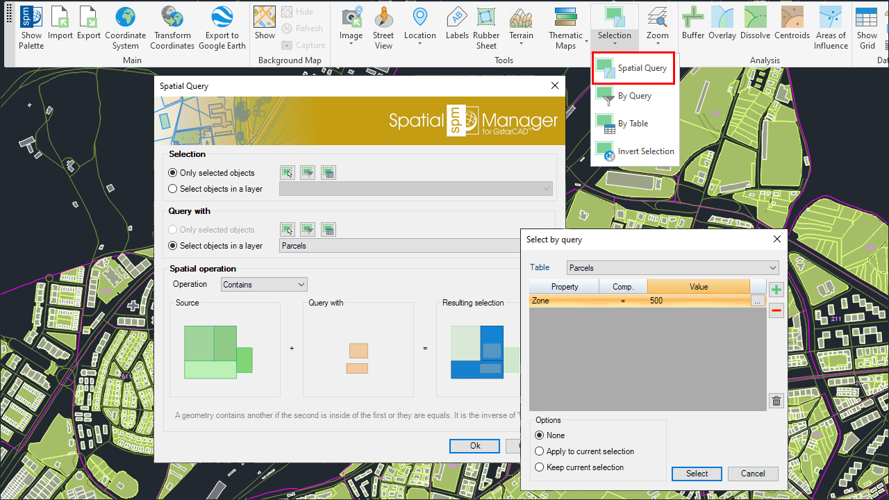
Can I define a selection of entities based on their geometric relationship?
The command 'SPMSPATIALQUERY' in 'Spatial Manager™ for GstarCAD' allows you select entities in the drawing according to the result of advanced simple or compound spatial queries

Advanced selection by processing Spatial Queries
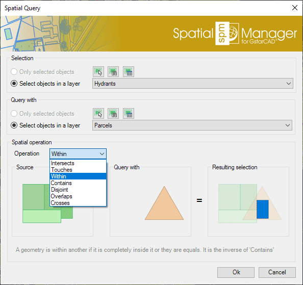
This function allows you to select entities in the drawing by performing "geometric operations" between two groups of entities: "Selection" (Group 1) and "Query with" (Group 2). For example, according to the chosen parameters in this image, all the Hydrants (points) that are located within a Parcel (polygons) would be selected
- Parameters and options
- Entities selection (Group 1 and Group 2)
- Only selected entities: A set of entities will be selected. You can select the entities before executing this command (for one of the Groups) or by using the Selecting buttons in this window
- Manual selection
- Select by Query: Select entities according to the result of a simplex or compound data query (See "Selecting by Query")
- Select by Table: Select entities which have been previously attached to a specific data table (See "Selecting by Table")
- Select entities in a layer: All the entities in a GstarCAD Layer will be selected. You can select the layer using the drop-down list in this window
- Only selected entities: A set of entities will be selected. You can select the entities before executing this command (for one of the Groups) or by using the Selecting buttons in this window
- Spatial operation
- Intersects: A geometry Intersects another one if they have at least a point in common. It is the opposite of 'Disjoint'. For example, combined with Buffers, entities that are located at a certain distance from other entities, which will normally be points or linear entities (such as buildings located at a certain distance from road or street axes, etc.)
- Touches: A geometry Touches another one if they have common points only at their boundaries, without intersection and no one of them contains or is equal to the other. For example, buildings touching another building within a block of contiguous buildings (the drawing must be very precise because no intersections should occur)
- Within: A geometry is Within another one if it is completely inside or they are equal. It is the inverse of 'Contains'. For example, to select points representing pharmacies within a neighborhood, polygons representing hospitals within a municipality or buildings within a parcel, etc.
- Contains: A geometry Contains another one if the second one is completely inside of the first one or they are equal. Is is the inverse of 'Within'. For example, to select all the parcels in a municipality that contain one or more buildings
- Disjoint: A geometry is Disjoint from another one if they do not have any points in common (that is, "out of": It does not intersect and does not touch). It is the opposite of 'Intersects'
- Overlaps: A geometry Overlaps another one if they have areas in common, but no one of them is fully inside the other one and they are not equal. For example, polygons that intersect, but none of them are completely inside each other, i.e., " they cross". A practical case could be the selection of buildings in one municipality that are located partially within the boundary of the municipality and partially within the boundary of another adjacent municipality
- Crosses: A geometry (linear entitiy) Crosses another one if it has at the same time parts inside and outside of the second one. For example, to select road sections that are partially located within the boundaries of two or more municipalities
- Entities selection (Group 1 and Group 2)
Note: You can use the command 'SPMZOOMTOSELECTION' (see below) to quickly zoom to the selection extent
Is there any way to locate on the screen all the selected entities?
Yes, the 'Spatial Manager™ for GstarCAD' 'SPMZOOMTOSELECTION' command, zooms to the current selection extent so you can locate all the selected entities in an optimal size view
")

Note: This functionality can be very handy as a complement to the previous selection commands, but also if it is used with other GstarCAD selection functions
Related links
- Blog posts
- Combine Quick select and Select by Query
- Locating polygons crossed by specific linear entities
- Developed for other CAD applications prior to the release of Spatial Manager™ for GstarCAD but also applicable
![]()
![]()