Difference between revisions of "Spatial Manager™ for GstarCAD - FAQs: Street View ("Professional" edition only)"
(Created page with "150px|link=https://www.spatialmanager.com/spm-forgstarcad/ |Spatial Manager™ for GstarCAD product page image:SPM GstarCAD Wiki t...") |
m |
||
| Line 76: | Line 76: | ||
==Related links== | ==Related links== | ||
| − | |||
| − | |||
| − | |||
Revision as of 18:28, 19 June 2021
![]()
![]()
Notes:
- Some components in the images on this page (providers, names, windows look, etc.) may be slightly different from those that will appear on your computer
- Some application functions need to access the Internet from the application itself. If you experiment problems in any process, ask your network administrator if there is a Proxy server installed on your network. You can configure the Proxy settings through the application options
Introduction
- Objective of this section
- To learn how to search for locations (Postal addresses, streets, neighborhoods or other geographical objects) in your drawings based on a search text
- Topics in this section
- Access the location search by text
- Review the search results and the related data shown in the search window
- Zoom to any selected result
- Insert the geometry or envelope of any selected result
How can I search for locations of geographical objects in my drawing?
Spatial Manager™ for GstarCAD includes the 'SPMSEARCHLOCATION' command that allows you to search for locations through Internet location services based on your search text. Once you enter the search text (the more precise, the more accurate the location) and click “Search” (or press Enter), the results returned by these services (if found, one or more rseults) will be shown in the search window and include the following information:
- Name: Full location name. Although you can resize the window if you want, if the full text does not fit, scroll over and a tooltip will be shown
- Type: Location type. According to the classification provided by the localization service
- Geometry: Geometry type. Point, Line-string, Polygon, Multi-Polygon, etc. The icon represents in a simplified way the geometry type but you can scroll over it and a tooltip including the geometry type text will be shown
- Source: Location service source. The name of the Internet location service that returned the result
You can sort the result rows according to the “Name”, “Type” or “Source” columns (direct or inverse order) by clicking on the column title

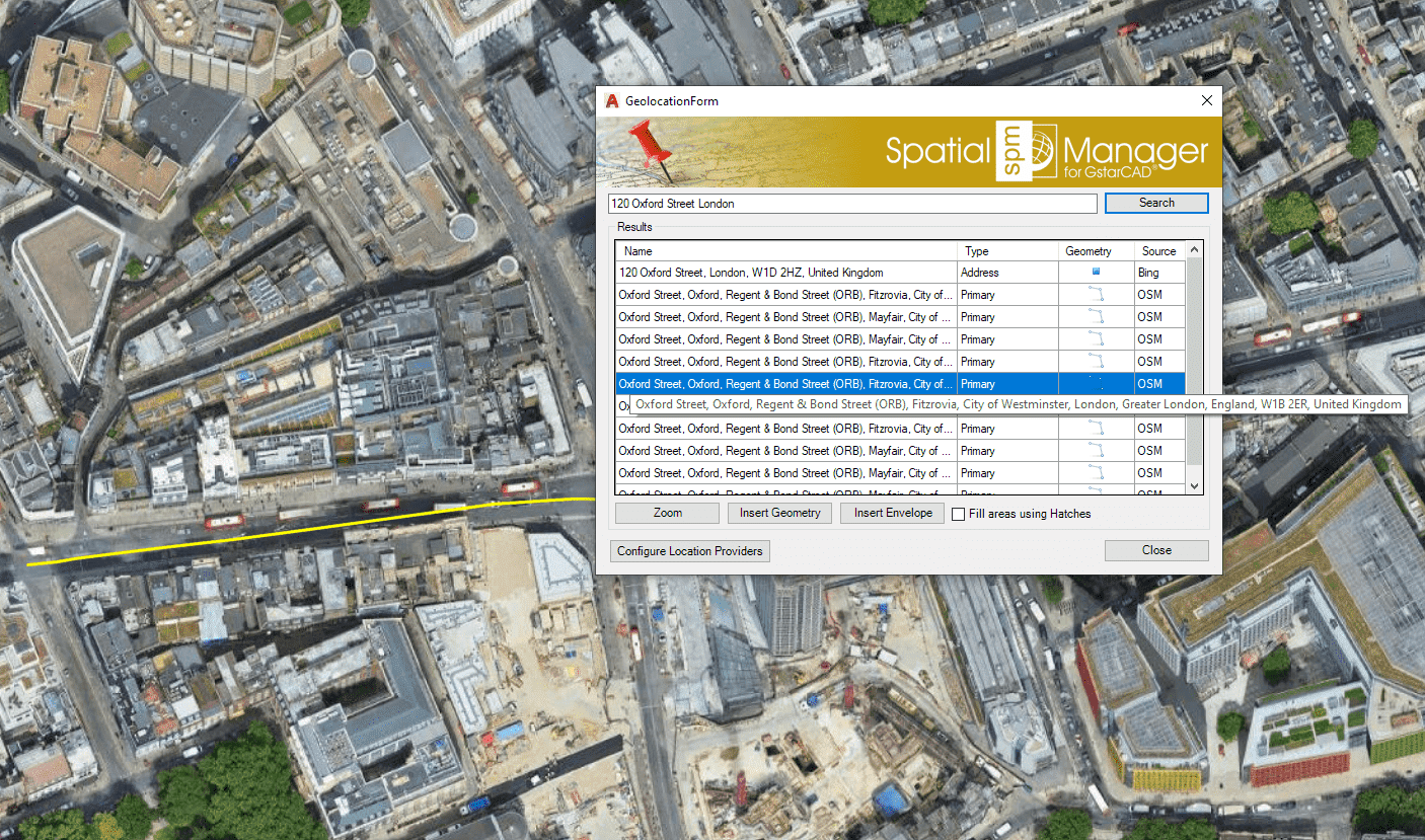
'Search Location' window
How can I use the results shown in the 'Search Location' window?
The Spatial Manager™ for GstarCAD 'Search Location' window allows you to select any shown result in order to:
- Zoom to the location. By using the "Zoom" button or by double-clicking on the chosen result
- Insert the Geometry in your drawing, and zoom to the Geometry. Points, Polylines, Polygons, etc., depending on the geometry type
- Insert the geometry Envelope, and zoom to the Envelope. Internet location services usually also return a rectangular envelope of the geographic object found. This option allows you to insert this rectangle in your drawing
You can choose “Fill areas using Hatches” in order to add a Hatch when inserting Polygonal geometries or rectangular Envelopes. The inserted objects (and their optional Hatches) will be drawn in the current Layer of the drawing
Note that the ‘Search Location’ window remains open until you close it so that you can repeat the actions with the results you want. In fact, you can navigate through the drawing, edit the drawing, etc. while the window is still on screen
Need to have some reference in the drawing to use 'Search Location'?
If the drawing is not empty when 'SPMSEARCHLOCATION' is executed, it is necessary that the drawing has been assigned a Coordinate Reference System (CRS) in order that the application "knows how-to" insert the selected geometries. If this is not the case, you can assign a CRS to the drawing (and modify it) using the command 'SPMSETCRS' of Spatial Manager™ for GstarCAD. By executing this command, you will access the CRS catalog of the application where you can:
- Filter the CRSs by type (Geocentric, Projected, etc.). The type "Projected" will be selected by default because is the most common choice
- Choose a CRS by clicking on its row in the table
- Search CRSs by typing the search criteria in the "Search" box. You can type here as many words as you like separated by blanks. The application will find all the rows including all these words in any column of the table
- Unassign (undefine) the Coordinate System of the drawing, by choosing "Undefined CRS" (EPSG 0)
If the drawing is empty and has no coordinate system assigned to it, when 'SPMSEARCHLOCATION' is executed Spatial Manager™ for GstarCAD will assign the CRS Code:3857 (WGS84 / Pseudo-Mercator) to the drawing. This CRS is valid for any Earth area, but may be inaccurate for measurements in some areas. If you want to configure any other known local CRS, use the 'SPMSETCRS' command as explained above
- Notes:


CRS catalog of the application
Related links
![]()
![]()