Difference between revisions of "Spatial Manager™ for ZWCAD - FAQs: How to Start?"
m |
m |
||
| (37 intermediate revisions by 3 users not shown) | |||
| Line 1: | Line 1: | ||
| − | [[image:SPM ZWCAD Wiki to Website.png|150px|link= | + | [[image:SPM ZWCAD Wiki to Website.png|150px|link=https://www.spatialmanager.com/spm-forzwcad/ |Spatial Manager™ for ZWCAD product page]] [[image:SPM ZWCAD Wiki to Download.png|150px|link=https://www.spatialmanager.com/download/spatial-manager-zwcad/ |Download Spatial Manager™ for ZWCAD]] |
| − | '''''Important notice:''' | + | '''''Important notice:''' [https://www.spatialmanager.com/download/spatial-manager-zwcad/ <ins>Spatial Manager™ for ZWCAD</ins>] will run on ZWSOFT software v.2017 to v.2023 SP2 (more information about languages, older ZWCAD versions and other special details or exclusions on the page [[Spatial_Manager™_for_ZWCAD_-_FAQs:_Compatible_ZWCAD_applications | Compatible ZWCAD applications]]) |
| Line 11: | Line 11: | ||
| − | ''Have you downloaded the setup program? If not, you need to download it from the [ | + | ''Have you downloaded the setup program? If not, you need to download it from the [https://www.spatialmanager.com/download/spatial-manager-zwcad/ Spatial Manager™ for ZWCAD download link]'' |
| Line 18: | Line 18: | ||
**''32-bit and 64-bit versions: There are 32-bit and 64-bit versions of Spatial Manager™ for ZWCAD but you do not need to worry about what platform is selected because the setup program automatically chooses the same version as the ZWCAD installed'' | **''32-bit and 64-bit versions: There are 32-bit and 64-bit versions of Spatial Manager™ for ZWCAD but you do not need to worry about what platform is selected because the setup program automatically chooses the same version as the ZWCAD installed'' | ||
**''If the installation process does not produce any errors but later you cannot execute any 'Spatial Manager™ for ZWCAD' commands and/or the application's user interface does not appear in ZWCAD, please run ZWCAD "as administrator" and try again'' | **''If the installation process does not produce any errors but later you cannot execute any 'Spatial Manager™ for ZWCAD' commands and/or the application's user interface does not appear in ZWCAD, please run ZWCAD "as administrator" and try again'' | ||
| − | **''"Quiet" setup: You can install the application in "quiet" mode using the "/quiet" parameter, which will adopt the default values (installation path, etc.) and it will not be necessary to follow the installation process step by step. For example, from | + | **''"Quiet" setup: You can install the application in "quiet" mode using the "/quiet" parameter, which will adopt the default values (installation path, etc.) and it will not be necessary to follow the installation process step by step. For example, from the Windows command line you can execute: [Path]/SpatialManagerforZWCAD-X.exe /quiet'' |
***''"[Path]" is any local or networked path, where the installation EXE file can be found'' | ***''"[Path]" is any local or networked path, where the installation EXE file can be found'' | ||
***''"X" is the release number of the application'' | ***''"X" is the release number of the application'' | ||
| Line 27: | Line 27: | ||
| − | [[Image:SpatialManagerforZWCAD-Icon.png|border]] | + | [[Image:SpatialManagerforZWCAD-Icon.png|border|link=]] |
Finally, when you install Spatial Manager™ for ZWCAD, the setup application also adds the Interface components to ZWCAD and a Sample data set including some spatial files to your system. Watch this short video and follow the next steps to learn how to start using the application and to check that everything works fine | Finally, when you install Spatial Manager™ for ZWCAD, the setup application also adds the Interface components to ZWCAD and a Sample data set including some spatial files to your system. Watch this short video and follow the next steps to learn how to start using the application and to check that everything works fine | ||
| − | *'' | + | ''Notes:'' |
| − | *'' | + | *''The Sample data folder (and subfolders) is a read-only folder, so select another folder when trying to write data through Export processes, etc.'' |
| + | *''Some components in the images on this page (providers, names, windows look, etc.) may be slightly different from those that will appear on your computer'' | ||
| + | *''Some application functions need to access the Internet from the application itself. If you experiment problems in any process, ask your network administrator if there is a Proxy server installed on your network. You can configure the [[Spatial_Manager%E2%84%A2_for_ZWCAD_-_FAQs:_Interface#Options|Proxy settings through the application options]]'' | ||
| + | *''Some geographic data providers (Geocode, image Maps, etc.) may need a user account, which you can configure in the [[Spatial_Manager%E2%84%A2_for_ZWCAD_-_FAQs:_Interface#Options|Service Provider API Keys settings through the application options]]'' | ||
| Line 40: | Line 43: | ||
*Start ZWCAD and create a new drawing | *Start ZWCAD and create a new drawing | ||
| − | * | + | *Options to access the application Commands |
| − | ** | + | **New "Spatial Manager" tab in the ZWCAD Ribbon (if the Ribbon is available) |
| − | ** | + | **New "Spatial Manager" Toolbar |
| − | ** | + | **New "Spatial Manager" drop-down Menu |
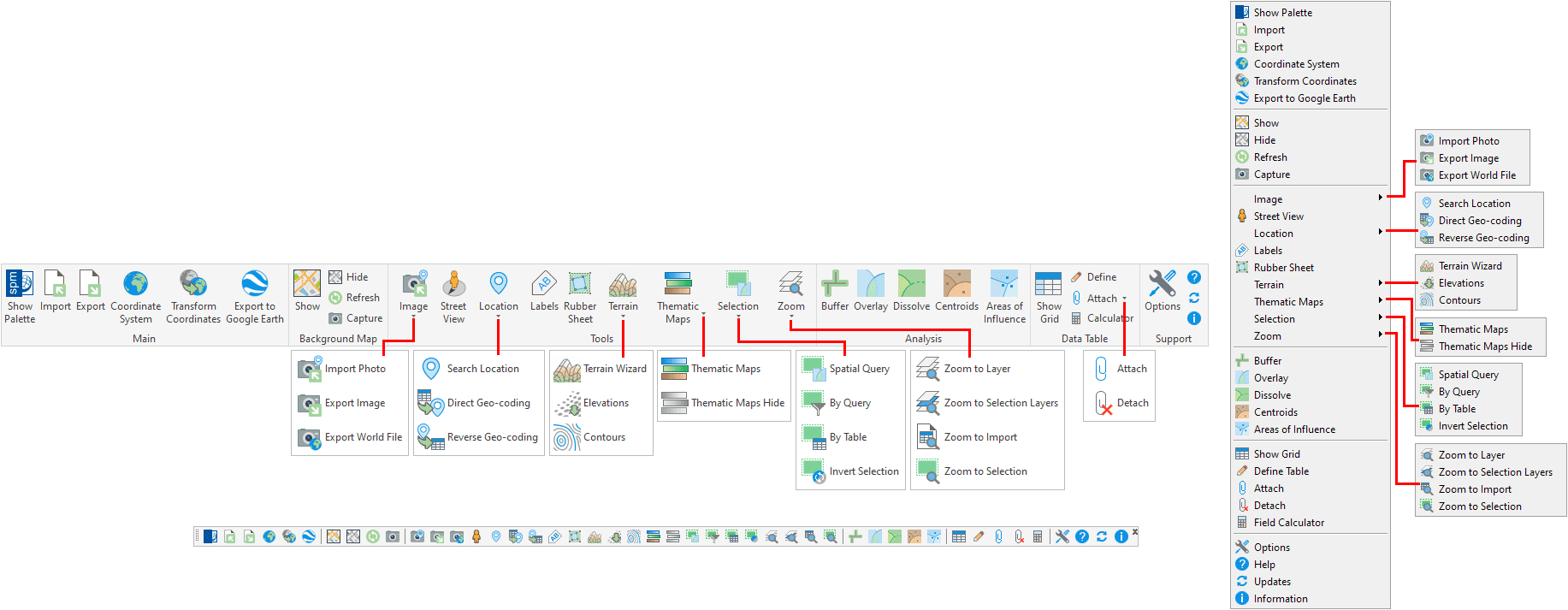
| − | [[Image: | + | <span title="Spatial Manager™ for ZWCAD Interface">[[Image:CADInterface-Clean2.png|1400px|Spatial Manager™ for ZWCAD Interface|link={{filepath:CADInterface-Clean2.png}}]]</span> |
| + | *Click on the "Show Palette" button to open the SPATIALMANAGER palette, which includes the main functions of Spatial Manager™ for ZWCAD | ||
| + | **If you cannot or you do not want to access to the Ribbon, Toolbar o Menu, key in "SPM" in the Command line to open the palette | ||
*Expand the "Sample data" Shortcut to access the sample Shapefiles (SHP) | *Expand the "Sample data" Shortcut to access the sample Shapefiles (SHP) | ||
*Right-click over any Shapefile (SHP) to import the spatial information as ZWCAD Entities into the current drawing or into a new drawing | *Right-click over any Shapefile (SHP) to import the spatial information as ZWCAD Entities into the current drawing or into a new drawing | ||
*Use the default parameters in all the Wizard windows | *Use the default parameters in all the Wizard windows | ||
*Check the imported ZWCAD Entities | *Check the imported ZWCAD Entities | ||
| − | **Note for Trial version users: take a look to the application [ | + | **Note for Trial version users: take a look to the application [https://wiki.spatialmanager.com/index.php/Spatial_Manager%E2%84%A2_for_ZWCAD_-_FAQs:_Licenses#What_is_the_.22Trial_version.22_of_the_application.3F Limitations in this Version] |
*Import more Shapefiles (SHP) into the same drawing or into new drawings while choosing different import options | *Import more Shapefiles (SHP) into the same drawing or into new drawings while choosing different import options | ||
*Try to import other kind of spatial files such as Google Earth KML, GPS/GPX, SQLite or XYZ point files | *Try to import other kind of spatial files such as Google Earth KML, GPS/GPX, SQLite or XYZ point files | ||
| Line 72: | Line 77: | ||
*[[Spatial Manager™ for ZWCAD - FAQs: Import | Import processes, parameters, coordinate transformation, extended data, tasks]] | *[[Spatial Manager™ for ZWCAD - FAQs: Import | Import processes, parameters, coordinate transformation, extended data, tasks]] | ||
*[[Spatial Manager™ for ZWCAD - FAQs: Export ("Professional" edition only) | Export processes, parameters, coordinate transformation, export to Google Earth, extended data]] ("Professional" edition only, except "Export to Google Earth" on "Standard" and "Professional" editions) | *[[Spatial Manager™ for ZWCAD - FAQs: Export ("Professional" edition only) | Export processes, parameters, coordinate transformation, export to Google Earth, extended data]] ("Professional" edition only, except "Export to Google Earth" on "Standard" and "Professional" editions) | ||
| − | *[[Spatial Manager™ for ZWCAD - FAQs: Data Structure Management ("Standard" and "Professional" editions only) | Create or edit data tables, attach, detach or select entities]] ("Standard" and "Professional" editions only'') | + | *[[Spatial Manager™ for ZWCAD - FAQs: Data Structure Management ("Standard" and "Professional" editions only) | Create or edit data tables, attach, detach, label or select entities]] ("Standard" and "Professional" editions only'') |
| + | *[[Spatial Manager™ for ZWCAD - FAQs: Thematic Maps ("Professional" edition only) | Thematic Maps: Visualize entities according to data fields values]] ("Professional" edition only'') | ||
| + | *[[Spatial Manager™ for ZWCAD - FAQs: Advanced Selection ("Standard" and "Professional" editions only) | Select by data Table, data Query or Spatial Query]] ("Standard" and "Professional" editions only'') | ||
| + | *[[Spatial Manager™ for ZWCAD - FAQs: GIS Analysis ("Professional" edition only) | Buffers, Overlays, Dissolutions, Centroids, Areas of Influence ]] ("Professional" edition only'') | ||
| + | *[[Spatial Manager™ for ZWCAD - FAQs: Transform drawings Coordinate System ("Professional" edition only) | Transform the drawing between two Coordinate Systems]] ("Professional" edition only'') | ||
*[[Spatial Manager™ for ZWCAD - FAQs: Background Maps ("Standard" and "Professional" editions only) | Use Background image Maps, reference Maps]] ("Standard" and "Professional" editions only'') | *[[Spatial Manager™ for ZWCAD - FAQs: Background Maps ("Standard" and "Professional" editions only) | Use Background image Maps, reference Maps]] ("Standard" and "Professional" editions only'') | ||
*[[Spatial Manager™ for ZWCAD - FAQs: Terrains ("Professional" edition only) | Create elevation 3D Points, 2D or 3D Contours or Terrain 3D models]] ("Professional" edition only'') | *[[Spatial Manager™ for ZWCAD - FAQs: Terrains ("Professional" edition only) | Create elevation 3D Points, 2D or 3D Contours or Terrain 3D models]] ("Professional" edition only'') | ||
| + | *[[Spatial Manager™ for ZWCAD - FAQs: Search Location ("Professional" edition only) | Search for Locations of geographical objects in the drawing]] ("Professional" edition only'') | ||
| + | *[[Spatial Manager™ for ZWCAD - FAQs: Geo-Coding ("Professional" edition only) | Geo-coding postal addresses (Direct and Reverse)]] ("Professional" edition only'') | ||
| + | *[[Spatial Manager™ for ZWCAD - FAQs: Street View ("Professional" edition only) | Drawing Street View display and navigation]] ("Professional" edition only'') | ||
*[[Spatial Manager™ for ZWCAD - FAQs: Application Programming Interface (API) ("Professional" edition only) | Application Programming Interface (API)]] ("Professional" edition only'') | *[[Spatial Manager™ for ZWCAD - FAQs: Application Programming Interface (API) ("Professional" edition only) | Application Programming Interface (API)]] ("Professional" edition only'') | ||
| Line 82: | Line 94: | ||
*[[Coordinate Systems objects list | Coordinate Systems objects list]] | *[[Coordinate Systems objects list | Coordinate Systems objects list]] | ||
*[[Spatial Manager™ for ZWCAD EULA | End User License Agreement]] | *[[Spatial Manager™ for ZWCAD EULA | End User License Agreement]] | ||
| − | *[ | + | *[https://www.spatialmanager.com Spatial Manager™ web] |
==Related links== | ==Related links== | ||
| − | *[ | + | *Blog posts |
| + | **[https://www.spatialmanager.com/repair-when-adding-more-autocad-or-bricscad-products/ “Repair” when adding or updating products ''(also applicable in Spatial Manager™ for ZWCAD)''] | ||
| − | [[image:SPM ZWCAD Wiki to Website.png|150px|link= | + | [[image:SPM ZWCAD Wiki to Website.png|150px|link=https://www.spatialmanager.com/spm-forzwcad/ |Spatial Manager™ for ZWCAD product page]] [[image:SPM ZWCAD Wiki to Download.png|150px|link=https://www.spatialmanager.com/download/spatial-manager-zwcad/ |Download Spatial Manager™ for ZWCAD]] |
Revision as of 11:52, 7 December 2022
![]()
![]()
Important notice: Spatial Manager™ for ZWCAD will run on ZWSOFT software v.2017 to v.2023 SP2 (more information about languages, older ZWCAD versions and other special details or exclusions on the page Compatible ZWCAD applications)
A powerful ZWCAD plug-in but, how to Start it?
If you come here from the shortcut that starts the application, go directly to the paragraph below that starts: "Finally, when you install Spatial Manager™ for ZWCAD, the setup application..."
Have you downloaded the setup program? If not, you need to download it from the Spatial Manager™ for ZWCAD download link
First of all you need to install Spatial Manager™ for ZWCAD by executing the setup program. The name of the file to run will be different for each release of the application. It will appear as follows: SpatialManagerforZWCAD-X.exe, where "X" is the release number of the application
- Notes:
- 32-bit and 64-bit versions: There are 32-bit and 64-bit versions of Spatial Manager™ for ZWCAD but you do not need to worry about what platform is selected because the setup program automatically chooses the same version as the ZWCAD installed
- If the installation process does not produce any errors but later you cannot execute any 'Spatial Manager™ for ZWCAD' commands and/or the application's user interface does not appear in ZWCAD, please run ZWCAD "as administrator" and try again
- "Quiet" setup: You can install the application in "quiet" mode using the "/quiet" parameter, which will adopt the default values (installation path, etc.) and it will not be necessary to follow the installation process step by step. For example, from the Windows command line you can execute: [Path]/SpatialManagerforZWCAD-X.exe /quiet
- "[Path]" is any local or networked path, where the installation EXE file can be found
- "X" is the release number of the application
- Note also that this command can be executed from a batch file (*.bat), which will facilitate the deployment of network or remote installations
Next, you will see the Spatial Manager™ for ZWCAD icon placed on the Windows Desktop, which will let you return to this Wiki page anytime you want to
![]()
Finally, when you install Spatial Manager™ for ZWCAD, the setup application also adds the Interface components to ZWCAD and a Sample data set including some spatial files to your system. Watch this short video and follow the next steps to learn how to start using the application and to check that everything works fine
Notes:
- The Sample data folder (and subfolders) is a read-only folder, so select another folder when trying to write data through Export processes, etc.
- Some components in the images on this page (providers, names, windows look, etc.) may be slightly different from those that will appear on your computer
- Some application functions need to access the Internet from the application itself. If you experiment problems in any process, ask your network administrator if there is a Proxy server installed on your network. You can configure the Proxy settings through the application options
- Some geographic data providers (Geocode, image Maps, etc.) may need a user account, which you can configure in the Service Provider API Keys settings through the application options
- Start ZWCAD and create a new drawing
- Options to access the application Commands
- New "Spatial Manager" tab in the ZWCAD Ribbon (if the Ribbon is available)
- New "Spatial Manager" Toolbar
- New "Spatial Manager" drop-down Menu
- Click on the "Show Palette" button to open the SPATIALMANAGER palette, which includes the main functions of Spatial Manager™ for ZWCAD
- If you cannot or you do not want to access to the Ribbon, Toolbar o Menu, key in "SPM" in the Command line to open the palette
- Expand the "Sample data" Shortcut to access the sample Shapefiles (SHP)
- Right-click over any Shapefile (SHP) to import the spatial information as ZWCAD Entities into the current drawing or into a new drawing
- Use the default parameters in all the Wizard windows
- Check the imported ZWCAD Entities
- Note for Trial version users: take a look to the application Limitations in this Version
- Import more Shapefiles (SHP) into the same drawing or into new drawings while choosing different import options
- Try to import other kind of spatial files such as Google Earth KML, GPS/GPX, SQLite or XYZ point files
- Note about Coordinate Reference Systems (CRS): if you want to merge into the same drawing spatial data which has been saved using differents CRSs, you need to Transform the Coordinates of the incoming data so that they are consistent with each other. This can help you learn how the Coordinate Transformation works in the application. In the sample data set, the Shapefiles (SHP) and the SQLite and XYZ files were saved using the CRS "WGS 84 / Pseudo-Mercator" (SRID=3857), and the KML and GPX files were saved using the CRS "WGS 84" (SRID=4326) (mandatory for these formats)
So what now?
Now you can try to import your own spatial data and create your own Shortcuts and User Data Sources. We recommend you take a look to these Wiki pages to learn more about:
- Application introduction, main features, demo videos, Commands list
- Licenses, activation, support, updates, purchasing options
- Current compatible ZWCAD applications
- Application Data Providers
- Interface, Wizards, Options, Configurations
- Data sources, Shortcuts, User Data Sources
- Spatial files
- Databases, Data stores
- Import processes, parameters, coordinate transformation, extended data, tasks
- Export processes, parameters, coordinate transformation, export to Google Earth, extended data ("Professional" edition only, except "Export to Google Earth" on "Standard" and "Professional" editions)
- Create or edit data tables, attach, detach, label or select entities ("Standard" and "Professional" editions only)
- Thematic Maps: Visualize entities according to data fields values ("Professional" edition only)
- Select by data Table, data Query or Spatial Query ("Standard" and "Professional" editions only)
- Buffers, Overlays, Dissolutions, Centroids, Areas of Influence ("Professional" edition only)
- Transform the drawing between two Coordinate Systems ("Professional" edition only)
- Use Background image Maps, reference Maps ("Standard" and "Professional" editions only)
- Create elevation 3D Points, 2D or 3D Contours or Terrain 3D models ("Professional" edition only)
- Search for Locations of geographical objects in the drawing ("Professional" edition only)
- Geo-coding postal addresses (Direct and Reverse) ("Professional" edition only)
- Drawing Street View display and navigation ("Professional" edition only)
- Application Programming Interface (API) ("Professional" edition only)
And some useful links to other pages of Spatial Manager™ for ZWCAD:
Related links
- Blog posts
![]()
![]()