Difference between revisions of "Spatial Manager™ for ZWCAD - FAQs: Thematic Maps ("Professional" edition only)"
m |
m |
||
| Line 7: | Line 7: | ||
*''Some application functions need to access the Internet from the application itself. If you experiment problems in any process, ask your network administrator if there is a Proxy server installed on your network. You can configure the [[Spatial_Manager%E2%84%A2_for_ZWCAD_-_FAQs:_Interface#Options|Proxy settings through the application options]]'' | *''Some application functions need to access the Internet from the application itself. If you experiment problems in any process, ask your network administrator if there is a Proxy server installed on your network. You can configure the [[Spatial_Manager%E2%84%A2_for_ZWCAD_-_FAQs:_Interface#Options|Proxy settings through the application options]]'' | ||
*''Some geographic data providers (Geocode, image Maps, etc.) may need a user account, which you can configure in the [[Spatial_Manager%E2%84%A2_for_ZWCAD_-_FAQs:_Interface#Options|Service Provider API Keys settings through the application options]]'' | *''Some geographic data providers (Geocode, image Maps, etc.) may need a user account, which you can configure in the [[Spatial_Manager%E2%84%A2_for_ZWCAD_-_FAQs:_Interface#Options|Service Provider API Keys settings through the application options]]'' | ||
| + | |||
| + | |||
| + | '''''Note: Thematic Maps were introduced in the version 8 of the application, so [[Spatial_Manager%E2%84%A2_for_ZWCAD_-_FAQs:_Compatible_ZWCAD_applications|are not available for some old ZWSOFT products]]'''' | ||
Revision as of 13:11, 24 August 2022
![]()
![]()
Notes:
- Some components in the images on this page (providers, names, windows look, etc.) may be slightly different from those that will appear on your computer
- Some application functions need to access the Internet from the application itself. If you experiment problems in any process, ask your network administrator if there is a Proxy server installed on your network. You can configure the Proxy settings through the application options
- Some geographic data providers (Geocode, image Maps, etc.) may need a user account, which you can configure in the Service Provider API Keys settings through the application options
Note: Thematic Maps were introduced in the version 8 of the application, so are not available for some old ZWSOFT products'
Introduction
- Objective of this section
- To learn how to change the visual appearance of entities depending on the values of a data field of an associated table (Thematic Map)
- Topics in this section
- Definition of new Thematic Maps
- Choose the type of a new Thematic Map
- Auto-generation of Styles
- Styles creation, deletion and editing
- Thematic colors of entities and optional fills
- Management of Thematic Maps from the application Explorer
- Activation and deactivation of Thematic Maps
How can I graphically represent in the drawing the Data values attached to the entities?
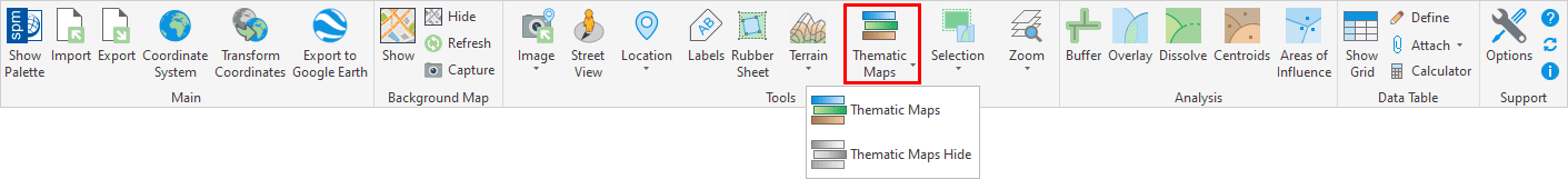
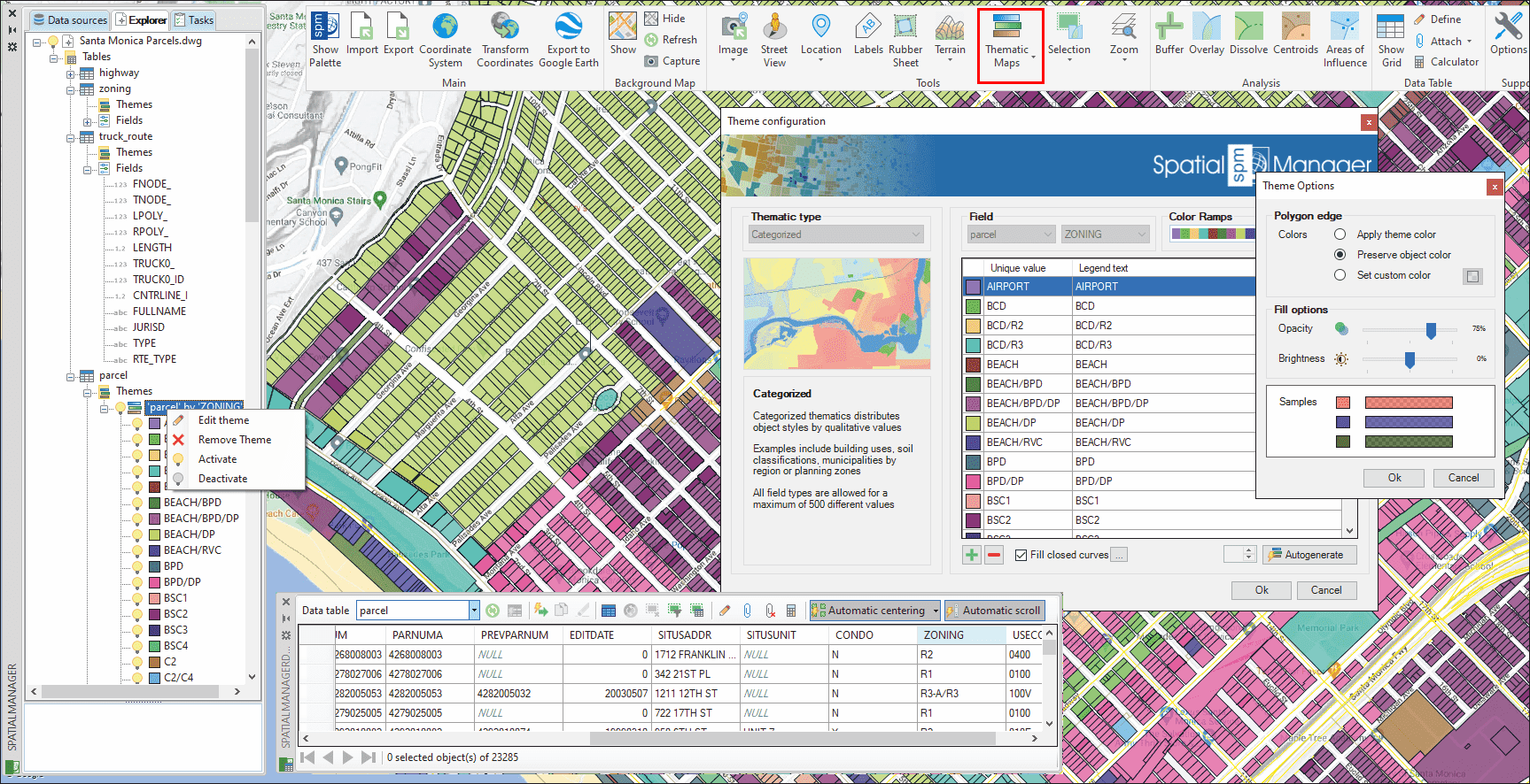
Spatial Manager™ for ZWCAD includes the Thematic Maps functionality, which allows to temporarily change the entities color in the drawing according to their associated alphanumeric data. You can define a new Thematic Map using the 'SPMTHEMATICMAP' command, whose window includes the definition of all the necessary parameters and options, as you can read below
In a drawing you can define as many Thematic Maps as you wish and activate or deactivate (return the display of entities to their native color) the Maps or any of the Styles. In addition, you can edit the colors and names of the Styles, and the visual update of the entities is Dynamic, i.e. if data values are modified while a Thematic Map is active, the colors will automatically change to reflect the new values of the affected entities
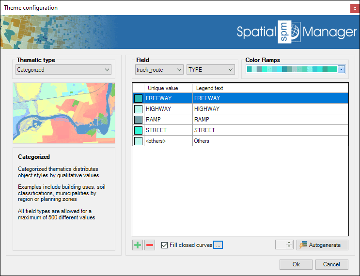
Thematic Maps in a drawing
In the Thematic Map definition (and edition) window all the parameters and options of the Map are specified:
- Thematic type
- Categorized: Distributes entity Styles by Qualitative values. Examples include building uses, soil classifications, municipalities by region, or planning zones. All field types are allowed for a maximum of 500 different values
- Graduated: Distributes entity Styles considering value Ranges. Examples include rivers by flow, buildings by height, or urban areas by population density. Numeric fields (including date/time) are allowed
- Graduated Gradient: Distributes entity Styles considering value/color Ranges, creating one or more Gradients. Examples include altimetry representations, or heat maps. Numeric fields (including date/time) are allowed
- Field
- Field in a Table whose values will be represented by the Thematic Map
- Color Ramps
- Although you can manually define and edit the Colors of each Style, the application includes a large number of predefined Color Ramps (single colors, gradients, etc.) that can be selected to assign these Colors. Even after selecting a Color Ramp, the Colors can be modified by the user for one more Styles of the Thematic Map
- Styles table
- Include the Color, Value (unique or values range) and Legend text for each Style in the Thematic Map. All these parameters can be customized
- The buttons below this table allow you to manually Add or Remove Styles. The Autogenerate button will automatically create the Styles of the Thematic Map for you based on the Values of the chosen field. In the case of Graduated Thematics, it is possible to define the number of "steps" in the range of the field Values
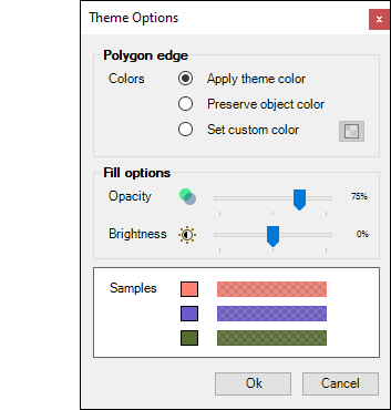
- In addition, it is possible to select whether to automatically Fill the closed entities that are part of the Thematic. In this case, the following Theme Options are available:
- Polygon edge
- Apply theme color: The entity Edges will be displayed in the color defined in the corresponding Style
- Preserve entity color: The entities Edges will be displayed in their native drawing color regardless of the color defined in the Style that corresponds to them
- Set custom color: A Custom color can be selected for all entity Edges regardless of the color defined in the Style that corresponds to them
- Fill options
- Here you can define the Opacity and Brightness levels for the resulting Hatches
- Polygon edge
How can I manage Thematic Maps in the drawing (add, delete, edit and activate/deactivate)?
You will find two ways in order to manage Thematic Maps: From the direct commands or from the application's Explorer
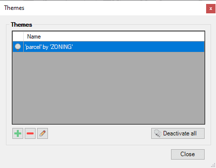
When you run the 'SPMTHEMATICMAP' command, if the drawing has no Thematic Maps defined, the definition window will appear, as you can read in the previous article. But if the drawing already has one or more Thematic Maps defined, the following window will appear, from which you can Add a new Thematic, and Delete or Edit any Thematic already defined. From this window you can also Deactivate all the Thematic Maps defined in the drawing, which is equivalent to running the command 'SPMTHEMATICMAPHIDE'
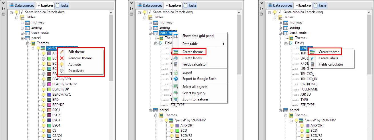
The second alternative, the application Explorer, is the most recommendable since, not only you will find many other functions included concerning the drawing, tables or fields, but you can also selectively activate/deactivate Styles of a Thematic, all this through contextual menus (right-click) and the use of the Thematic or Styles "light bulbs":
Related links
- Blog posts
![]()
![]()