Difference between revisions of "Spatial Manager Desktop™"
Jump to navigation
Jump to search
m |
m |
||
| (15 intermediate revisions by 2 users not shown) | |||
| Line 1: | Line 1: | ||
| − | [[image:SPM Desktop Wiki to Website.png|150px|link= | + | [[image:SPM Desktop Wiki to Website.png|150px|link=https://www.spatialmanager.com/spm-desktop/ |Spatial Manager Desktop™ product page]] [[image:SPM Desktop Wiki to Download.png|150px|link=https://www.spatialmanager.com/download/spatial-manager-desktop/ |Download Spatial Manager Desktop™]] |
| + | |||
| + | ==Introduction== | ||
| + | '''Spatial Manager Desktop™''' is a Windows desktop application designed to manage spatial data in a simple, fast and inexpensive way. Developed by a group of professionals working in the areas of GIS, Planning, Infrastructure and Civil Engineering, it provides the user with powerful tools to address the most common tasks of management and operation in the world of spatial information | ||
''Notes:'' | ''Notes:'' | ||
| + | |||
| + | *''Some functions or options may not be available in older versions. Please review the [[Spatial_Manager_Desktop™#FAQs | instructions and notes in each FAQs section]] because they describe the functional limitations for these versions'' | ||
*''Some components in the images on this page (providers, names, windows look, etc.) may be slightly different from those that will appear on your computer'' | *''Some components in the images on this page (providers, names, windows look, etc.) may be slightly different from those that will appear on your computer'' | ||
*''Some application functions need to access the Internet from the application itself. If you experiment problems in any process, ask your network administrator if there is a Proxy server installed on your network. You can configure the [[Spatial_Manager_Desktop%E2%84%A2_-_FAQs:_Interface#Options|Proxy settings through the application options]]'' | *''Some application functions need to access the Internet from the application itself. If you experiment problems in any process, ask your network administrator if there is a Proxy server installed on your network. You can configure the [[Spatial_Manager_Desktop%E2%84%A2_-_FAQs:_Interface#Options|Proxy settings through the application options]]'' | ||
| − | + | *''IMPORTANT: If you are using the trial version there are a number of limitations that [https://wiki.spatialmanager.com/index.php/Spatial_Manager_Desktop%E2%84%A2_-_FAQs:_Licenses#What_is_the_.22Trial_version.22_of_the_application.3F you can review here]'' | |
| − | |||
| − | |||
| − | |||
| − | '' | ||
| Line 43: | Line 44: | ||
*'''Data sources''' | *'''Data sources''' | ||
**Manage your own shortcuts | **Manage your own shortcuts | ||
| − | **Access to spatial data files (SHP, GPX, KML/KMZ, OSM, PBF, LAS/LAZ, CSV, TXT, ASC, XYZ, MIF/MID, TAB, E00, SQLite, SDF, GML, XML, etc.) | + | **Access to spatial data files (SHP, GPX, KML/KMZ, OSM, PBF, LAS/LAZ, GPKG, CSV, TXT, ASC, XYZ, MIF/MID, TAB, E00, SQLite, SDF, GML, XML, etc.) |
**Manage your User Data Sources ("Standard" and "Professional" editions only) | **Manage your User Data Sources ("Standard" and "Professional" editions only) | ||
**Access to spatial database servers (SQL Server, PostGIS, etc.) ("Standard" and "Professional" editions only) | **Access to spatial database servers (SQL Server, PostGIS, etc.) ("Standard" and "Professional" editions only) | ||
| Line 53: | Line 54: | ||
**Multiple data edition ("Standard" and "Professional" editions only) | **Multiple data edition ("Standard" and "Professional" editions only) | ||
**Remove unwanted features ("Standard" and "Professional" editions only) | **Remove unwanted features ("Standard" and "Professional" editions only) | ||
| − | **Save modified layers or new layers ("Standard" and "Professional" editions only)<br/><br/> | + | **Save modified layers or new layers ("Standard" and "Professional" editions only) |
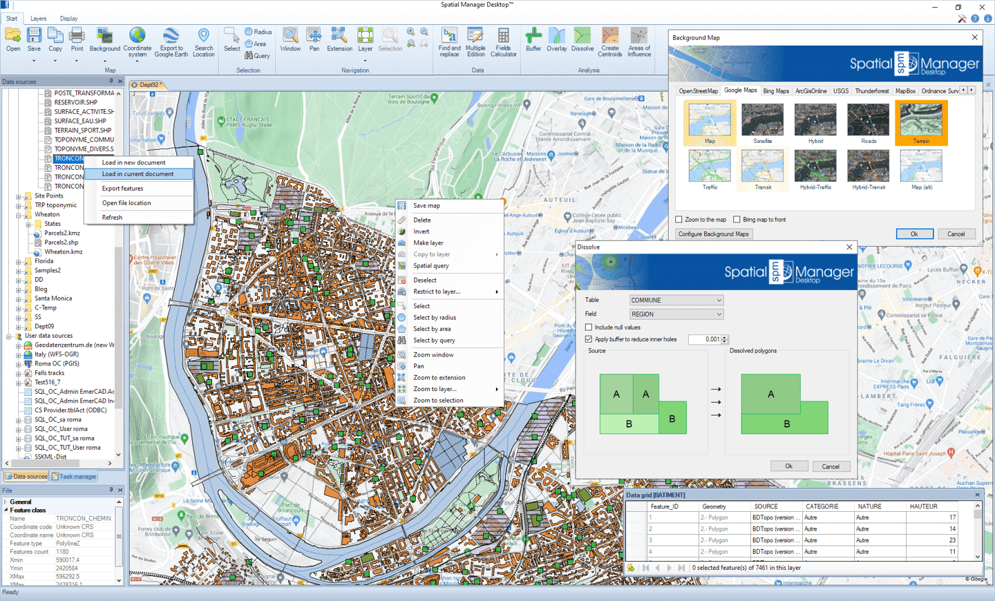
| + | **Process GIS analytical operations ("Professional" edition only) | ||
| + | ***Buffers | ||
| + | ***Overlays | ||
| + | ***Dissolve | ||
| + | ***Create Centroids | ||
| + | ***Areas of influence (Voronoi diagrams)<br/><br/> | ||
*'''Task & Processes''' | *'''Task & Processes''' | ||
**Import and export processes | **Import and export processes | ||
| Line 68: | Line 75: | ||
Just a few sample scenarios: | Just a few sample scenarios: | ||
| − | *[ | + | *[https://www.spatialmanager.com/spatial-manager-desktop-practical-part-1/ Why is Spatial Manager software so practical? (Part 1)] |
| − | *[ | + | *[https://www.spatialmanager.com/spatial-manager-desktop-practical-part-2/ Why is Spatial Manager software so practical? (Part 2)] |
| − | *[ | + | *[https://www.spatialmanager.com/spatial-manager-software-practical-part-3/ Why is Spatial Manager software so practical? (Part 3)] |
| Line 89: | Line 96: | ||
*[[Spatial Manager Desktop™ - FAQs: Selecting and filtering | Selecting and filtering Features]] | *[[Spatial Manager Desktop™ - FAQs: Selecting and filtering | Selecting and filtering Features]] | ||
*[[Spatial Manager Desktop™ - FAQs: Spatial queries | Layer Spatial Queries]] ("Standard" and "Professional" editions only) | *[[Spatial Manager Desktop™ - FAQs: Spatial queries | Layer Spatial Queries]] ("Standard" and "Professional" editions only) | ||
| + | *[[Spatial Manager Desktop™ - FAQs: GIS Analysis ("Professional" edition only) | Buffers, Overlays, Dissolutions, Centroids, Areas of Influence ]] ("Professional" edition only'') | ||
*[[Spatial Manager Desktop™ - FAQs: Data edition | Data edition]] | *[[Spatial Manager Desktop™ - FAQs: Data edition | Data edition]] | ||
*[[Spatial Manager Desktop™ - FAQs: Import and export | Import and export processes, parameters, Coordinate Transformation, export to Google Earth, Tasks]] | *[[Spatial Manager Desktop™ - FAQs: Import and export | Import and export processes, parameters, Coordinate Transformation, export to Google Earth, Tasks]] | ||
| Line 96: | Line 104: | ||
| − | *[ | + | *[https://www.spatialmanager.com/use-spatial-manager-wiki/ How to use the Spatial Manager Wiki? (Blog)] |
| Line 106: | Line 114: | ||
*[[Coordinate Systems objects list | Coordinate Systems objects list]] | *[[Coordinate Systems objects list | Coordinate Systems objects list]] | ||
*[[Spatial Manager Desktop™ EULA | End User License Agreement]] | *[[Spatial Manager Desktop™ EULA | End User License Agreement]] | ||
| − | *[ | + | *[https://www.spatialmanager.com Spatial Manager™ web] |
| − | [[image:SPM Desktop Wiki to Website.png|150px|link= | + | [[image:SPM Desktop Wiki to Website.png|150px|link=https://www.spatialmanager.com/spm-desktop/ |Spatial Manager Desktop™ product page]] [[image:SPM Desktop Wiki to Download.png|150px|link=https://www.spatialmanager.com/download/spatial-manager-desktop/ |Download Spatial Manager Desktop™]] |
Revision as of 18:50, 6 July 2021
![]()
![]()
Introduction
Spatial Manager Desktop™ is a Windows desktop application designed to manage spatial data in a simple, fast and inexpensive way. Developed by a group of professionals working in the areas of GIS, Planning, Infrastructure and Civil Engineering, it provides the user with powerful tools to address the most common tasks of management and operation in the world of spatial information
Notes:
- Some functions or options may not be available in older versions. Please review the instructions and notes in each FAQs section because they describe the functional limitations for these versions
- Some components in the images on this page (providers, names, windows look, etc.) may be slightly different from those that will appear on your computer
- Some application functions need to access the Internet from the application itself. If you experiment problems in any process, ask your network administrator if there is a Proxy server installed on your network. You can configure the Proxy settings through the application options
- IMPORTANT: If you are using the trial version there are a number of limitations that you can review here
Main features
- General
- Quickly stylize and manage maps
- Drag and drop spatial data to the maps
- Dynamic Background image Maps from Bing, OpenStreeMap, Mapbox, Ordnance Survey, NearMap, etc.
- Configurable user Maps. XYZ / TMS, WMTS and WMS compatible. WMS multi-layer maps
- Export/Import user Background Maps
- Smart systems for map opening
- Select and filter spatial features
- Alphanumeric queries
- Transformation of coordinates
- Export information to use in office or CAD apps.
- Printing of maps or selected features
- Properties panel viewer
- Query your spatial data ("Standard" and "Professional" editions only)
- Export the current status of the map to Google Earth (one click) ("Standard" and "Professional" editions only)
- Search the location of geographic objects ("Professional" edition only)
- Layer management
- Make new layers from selections or queries
- Project layers in maps
- Separate layers into new layers
- External and internal layers
- Disconnect layers from external sources
- Copy features to layers
- Data sources
- Manage your own shortcuts
- Access to spatial data files (SHP, GPX, KML/KMZ, OSM, PBF, LAS/LAZ, GPKG, CSV, TXT, ASC, XYZ, MIF/MID, TAB, E00, SQLite, SDF, GML, XML, etc.)
- Manage your User Data Sources ("Standard" and "Professional" editions only)
- Access to spatial database servers (SQL Server, PostGIS, etc.) ("Standard" and "Professional" editions only)
- Access to other connections (WFS, ODBC points or WKB - Excel, Access, dBase,...-, etc.) ("Standard" and "Professional" editions only)
- See current available Data Providers
- Edition
- Find and replace data ("Standard" and "Professional" editions only)
- Edit alphanumeric data ("Standard" and "Professional" editions only)
- Multiple data edition ("Standard" and "Professional" editions only)
- Remove unwanted features ("Standard" and "Professional" editions only)
- Save modified layers or new layers ("Standard" and "Professional" editions only)
- Process GIS analytical operations ("Professional" edition only)
- Buffers
- Overlays
- Dissolve
- Create Centroids
- Areas of influence (Voronoi diagrams)
- Task & Processes
- Import and export processes
- Automate processes using tasks ("Professional" edition only)
- Run tasks in the OS Command window ("Professional" edition only)
To get an overview of the application, please watch this video:
Just a few sample scenarios:
- Why is Spatial Manager software so practical? (Part 1)
- Why is Spatial Manager software so practical? (Part 2)
- Why is Spatial Manager software so practical? (Part 3)
FAQs
Here you will find all the technical information available on the implementation as well as tutorials, additional data, etc.
- How to Start?
- Licenses, activation, support, updates, purchasing options
- Application Data Providers
- Interface, Wizards, Options, Configurations
- Data sources, Shortcuts, User Data Sources
- Spatial files
- Databases, Data stores
- Maps, Layers, views
- Dynamic Background Maps
- Selecting and filtering Features
- Layer Spatial Queries ("Standard" and "Professional" editions only)
- Buffers, Overlays, Dissolutions, Centroids, Areas of Influence ("Professional" edition only)
- Data edition
- Import and export processes, parameters, Coordinate Transformation, export to Google Earth, Tasks
- Map Layers management
- Data use, export data, clipboard, printing
- Search for Locations of geographical objects in the map ("Professional" edition only)
Links
Here you will find some useful links to other pages of Spatial Manager Desktop™
![]()
![]()